Average temperatures overall with variable rainfall patterns
|
Temperature |
Temperatures were average (-0.50 to +0.50°C of average) for much of the country despite several cold snaps. Below average temperatures (0.51°C to 1.2°C below average) were observed in a few parts of the South Island including northern Tasman, much of Marlborough, Takaka, and eastern locations between Rakaia and Dunedin. Few isolated locations experienced above normal temperature (0.51°C to 1.2°C above average), mostly in the North Island. |
|
Rainfall |
Rainfall was below normal (50% to 79% of normal) over much of the southern portion of both islands (with a few exceptions) with well below normal rainfall (<50% of normal) observed in parts of the Wellington region and for southern West Coast, southwest Canterbury and northwest Otago in the South Island. Above normal (120% to 149% of normal) or well above normal (>149% of normal) rainfall levels were less widely observed, occurring in the Far North, locations between Kaipara and Hamilton (including Auckland), the Coromandel Peninsula, Nelson, and in parts of Otago, Tasman and Marlborough. |
|
Soil Moisture |
As of 1 October, soil moisture was near normal for most of New Zealand. Soils were drier than normal for coastal parts of the Gisborne and Wellington regions, and for inland Otago, southwest Canterbury, and a small part of north Canterbury near Culverdon. Wetter than normal soil moisture levels were restricted to very small patches along the east coast of the South Island near Kaikoura, Christchurch and Dunedin. |
Overview
September 2019 was characterised by lower than normal mean sea level pressure over and to the southeast of New Zealand with above normal pressure to the west. This pressure set up resulted in a southwest airflow anomaly across the country (i.e. more southwesterly winds than normal). Weather was highly variable throughout the month however with both warm subtropical winds and cool southerlies causing temperatures to transition from warm to cold at times. Additionally, cool temperatures were contributed to by the continued influence of a sudden stratospheric warming event (and associated polar jet stream) which started to unfold in the polar stratosphere during late August and peaked in mid-September (see Highlights and extreme events section for further details). Throughout the month, a few stretches of high pressure brought periods of calm conditions to much of New Zealand although several low pressure systems and associated fronts also brought unsettled weather to the country resulting in thunderstorms, high winds, and snowfall in various locations (see Highlights and extreme events section for further details).
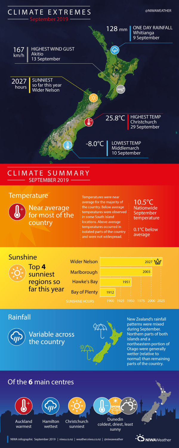
Temperatures were largely near average for the month as a whole. The nationwide average temperature in September 2019 was 10.5°C (0.1°C below the 1981-2010 September average from NIWA’s seven station temperature series which begins in 1909). The September 2019 temperature anomaly of -0.1˚C (i.e. weakly negative) is the greatest negative deviation from the 1981-2010 average of any month in the last two years (excluding April 2019 which was also -0.1˚C cooler than average). Additionally, September 2019 was the 4th coldest September this century, outranked by three much colder years with seven station temperature anomalies of -0.7°C in 2004 and -0.8°C in 2011 and 2015. It has now been 32 consecutive months since New Zealand experienced a nationwide average temperature that was below average (at least 0.51˚C below the 1981-2010 average).
Temperatures were below average (0.51°C to 1.2°C below average) for a few South Island locations including northern Tasman, much of Marlborough, Takaka, and in eastern locations between Rakaia and Dunedin where some temperatures were well below average (<1.2°C below average). A handful of isolated locations observed above average temperatures (0.51°C to 1.2°C above average) including Coromandel to East Auckland, Matamata, and Napier in the North Island as well as Cheviot in the South Island. Most of the country however experienced near average September temperatures (-0.50 to +0.50°C of average).
September rainfall was below normal (50% to 79% of normal) for much of the southern half of the North Island (excluding southern Hawke’s Bay) with parts of the Wellington region observing well below normal (<50% of normal) rainfall totals. Below or well below normal rainfall totals were also experienced in the western half of the South Island (south of Hokitaka) and in some eastern locations including southeast Otago, central Canterbury, and coastal north Canterbury. Above normal (120% to 149% of normal) or well above normal (>149% of normal) rainfall levels were less widely observed during September, occurring in the Far North, between Kaipara and Hamilton (including Auckland), Coromandel Peninsula, Nelson, and in parts of Otago, Tasman and Marlborough. Remaining locations experienced near normal (80 to 119% of normal) rainfall amounts.
Further Highlights:
- The highest temperature was 25.8°C, observed at Christchurch on 29 September.
- The lowest temperature was -8.0°C, observed at Middlemarch on 10 September.
- The highest 1-day rainfall was 128 mm, recorded at Whitianga (Airport) on 9 September.
- The highest wind gust was 167 km/h, observed at Akitio on 13 September.
- Of the six main centres in September 2019, Auckland was the warmest, Hamilton was the wettest, Christchurch was the sunniest, and Dunedin was the coldest, driest and least sunny.
- Of the available, regularly reporting sunshine observation sites, the sunniest four regions in 2019 so far are Wider Nelson (2027 hours), Marlborough (2003 hours), Hawke’s Bay (1951 hours), and Bay of Plenty (1912 hours).


