| Temperature | Temperatures were near average (±0.50°C of average) in many areas, although above average temperatures (0.51-1.20°C above average) were observed in parts of Northland, Coromandel Peninsula, Bay of Plenty, Gisborne, northern Hawke’s Bay, Wairarapa, southern Marlborough, Canterbury, and north-east Otago. Below average temperatures (0.51-1.20°C below average) covered parts of western Auckland, Waikato, Taranaki, West Coast, and northern Fiordland. |
| Rainfall | Below normal (50-79% of normal) or well below normal (<50% of normal) rainfall occurred in most regions of the country. However, near normal (80-119% of normal) rainfall was observed in parts of central Waikato, inland Manawatū-Whanganui, West Coast, and inland Southland. The remainder of Southland, Fiordland, and Stewart Island observed above normal (120-149% of normal) or well above normal (>149% of normal) rainfall. |
| Soil Moisture | At the end of February, soil moisture levels were lower than normal in parts of Northland, Auckland, Coromandel Peninsula, eastern Bay of Plenty, Gisborne, southern Hawke’s Bay, eastern Taranaki, Manawatū-Whanganui, Wellington-Wairarapa, eastern Tasman, Nelson, Marlborough, Canterbury, and eastern Otago. Normal or above normal soil moisture was observed elsewhere. According to the New Zealand Drought Index, very dry or extremely dry conditions were present in Northland, East Cape, southern Manawatū-Whanganui, Wellington-Wairarapa, eastern Tasman, Nelson, Marlborough, North Canterbury, and north-east Otago. |
Overview
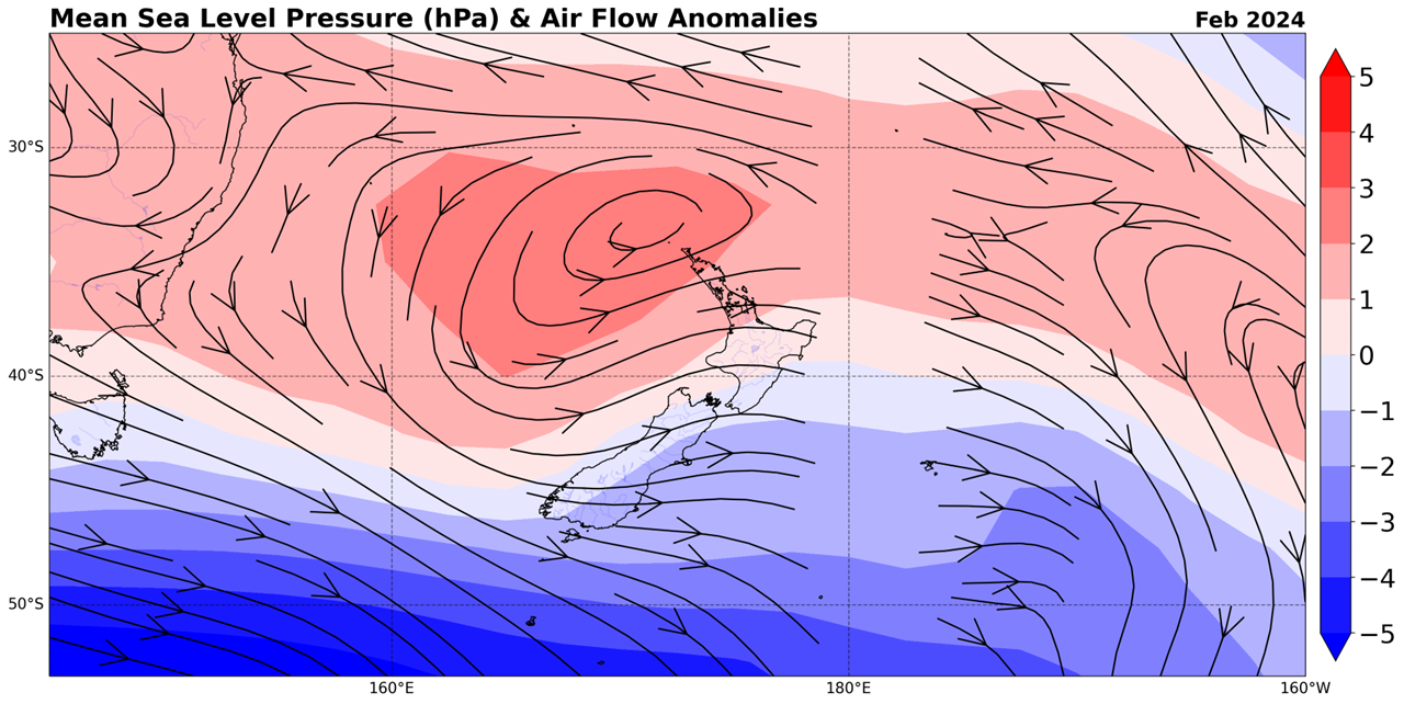
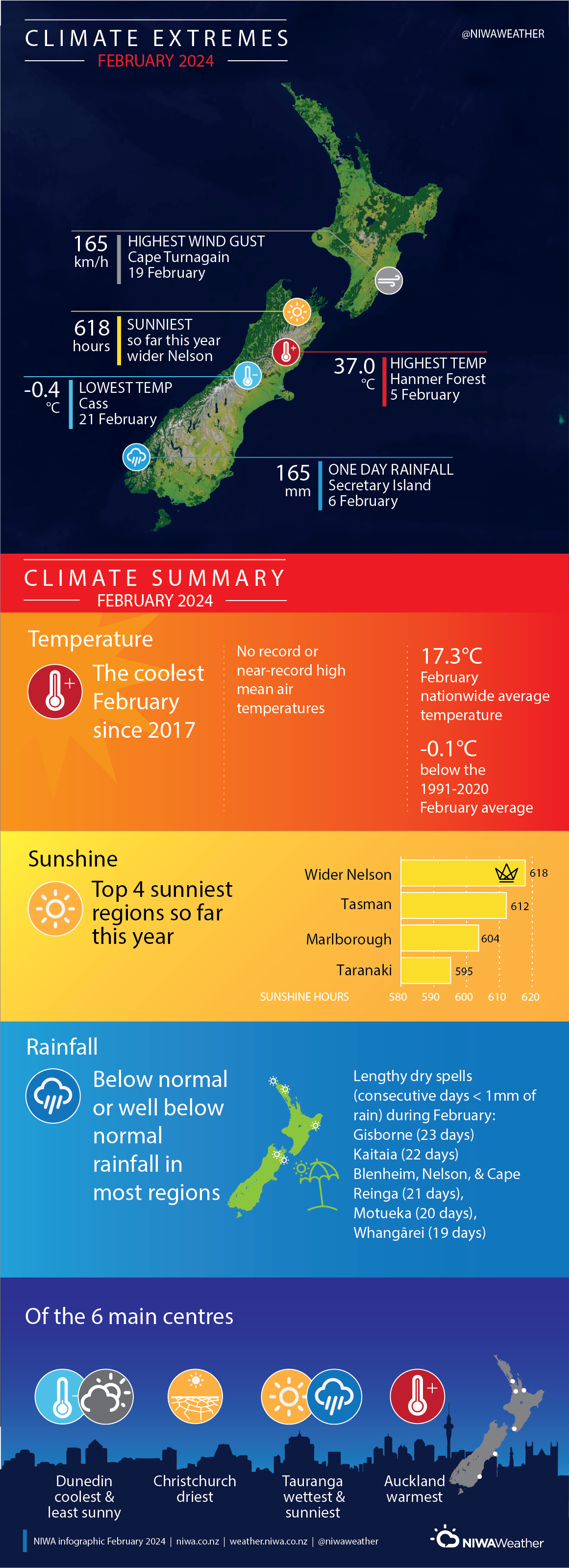
February 2024 was characterised by above normal mean sea level pressure (MSLP) in the northern Tasman Sea and near the North Island, with below normal MSLP near the South Island and in the Southern Ocean. This led to westerly airflows that were both more frequent and stronger than normal (Figure 1). This pattern was consistent with a strong, but waning, El Niño event in the equatorial Pacific. The nationwide average temperature in February 2024 was 17.3°C. This was 0.1°C below the 1991-2020 February average from NIWA’s seven station temperature series which begins in 1909, making it the coolest February since 2017.
The most notable climatic feature of the month was widespread below normal or well below normal rainfall, which occurred in most of the North Island and northern and eastern South Island – a stark contrast to February 2023. As far as temperatures go, above average temperatures were uncommon, with the bulk of both islands observing near average conditions. Below average temperatures lined west coastal areas of both islands, a rarity in New Zealand’s warming climate but consistent with stronger than normal westerly winds and cooler than average sea surface temperatures in parts of the western and northern South Island and western North Island.

Sunshine was abundant for wide swathes of the country, outside of northern Northland, coastal Manawatū-Whanganui, and Southland. A number of locations experienced their sunniest February on record, including Tākaka, Hokitika, Appleby, and Richmond, where 298 hours of sunshine were recorded. Auckland (Māngere) and Hamilton (Ruakura) experienced their 2nd-sunniest February on record with 260 hours and 253 hours of sunshine, respectively.
Further Highlights:
- The highest temperature was 37.0°C, observed at Hanmer Forest on 5 February.
- The lowest temperature was -0.4°C, observed at Cass (inland Canterbury) on 21 February.
- The highest 1-day rainfall was 165 mm, recorded at Secretary Island on 6 February.
- The highest wind gust was 165 km/h, observed at Cape Turnagain on 19 February.
- Of the six main centres in February 2024, Auckland was the warmest, Christchurch was the driest, Tauranga was the wettest and sunniest, and Dunedin was the coolest and least sunny.
- Of the available, regularly reporting sunshine observation sites, the sunniest four locations so far in 2024 are wider Nelson (618 hours), Tasman (612 hours), Marlborough (604 hours), and Taranaki (595 hours).

