Wet and cool for inland parts of the South Island, variable elsewhere.
|
Rainfall |
Above normal (120% to 149% of normal) or well above normal (>149% of normal) rainfall for much of inland Otago, southern Westland, Canterbury, Marlborough Wellington, Wairarapa and Taranaki. Below normal (50% to 79% of normal) or well below normal (<50% of normal) rainfall for eastern Southland, north Otago, Nelson and Tasman, Hawke’s Bay, eastern Waikato, western Bay of Plenty and Northland. |
|
Temperature |
Inland parts of Southland, Otago and Canterbury experienced below average (-0.51°C to -1.20°C of average) temperatures. In contrast, areas along the west coast of the South Island experienced above average (+0.51 to +1.20°C of average) temperatures. Temperatures were near average (‑0.50 to +0.50°C of average) for the majority of the North Island. |
|
Soil Moisture |
By the end of April, soils were drier than normal for northern and central parts of the North Island. Soils were also drier than normal for southern parts of Marlborough, north Otago and southern Southland. Soil moisture levels were above normal for northern Fiordland, western Otago, eastern Marlborough, Wellington and northern Taranaki. |
Overview
Overall, April 2019 was characterised by higher pressure than normal over the Tasman Sea and New Zealand. This resulted in more northerly winds than usual overall, however the prevailing area of high pressure over the Tasman Sea enabled several outbreaks of southerly airflow over New Zealand during the month. The lack of a consistent airflow anomaly during April resulted in a variety of rainfall and temperature patterns observed throughout the country. It was a wet and cool month for inland parts of the South Island, yet temperatures were mild for the time of year along the West Coast. For most of the North Island, temperatures were typical for April. It was a wet month for southern and western parts of the North Island, with most remaining areas of the island experiencing a drier April than usual.
There were relatively few significant weather events during the month, which is likely a result of the higher than normal air pressure observed over and to the west of New Zealand. The most notable event occurred towards the end of April, when a southerly blast brought areas of surface flooding and power outages to Christchurch and Banks Peninsula (refer to the highlights and extreme events section for further details).
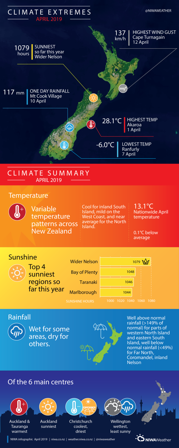
The nationwide average temperature in April 2019 was 13.1°C (0.1°C below the 1981-2010 April average from NIWA’s seven station temperature series which begins in 1909).
Further highlights
- The highest temperature was 28.1°C, observed at Akaroa on 1 April.
- The lowest temperature was -6.0°C, observed at Ranfurly on 7 April.
- The highest 1-day rainfall was 117 mm, recorded at Mt Cook Village on 10 April.
- The highest wind gust was 137 km/h, observed at Cape Turnagain on 12 April.
- Of the six main centres in April 2019, Auckland and Tauranga were the equal-warmest, Auckland was the sunniest, Christchurch was the driest and coolest, and Wellington was the wettest and least sunny.
- Of the available automatic sunshine observation sites, the sunniest four locations in 2019 so far (1 January – 30 April) are Wider Nelson (1079 hours), Bay of Plenty (1048 hours), Taranaki (1046 hours) and Marlborough (1044 hours).
Download
Climate summary April 2019 [PDF 350KB]
Climate statistics April 2019 [PDF 70KB]


