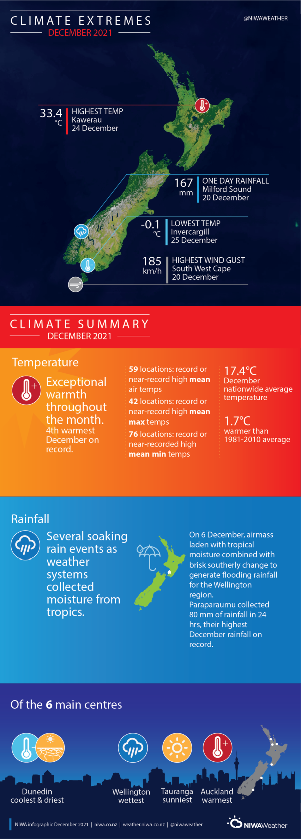
New Zealand’s 4th-warmest December on record
|
Temperature |
December 2021 was New Zealand’s 4th-warmest December on record. Temperatures were well above average (>1.20°C above average) across the entire North Island and the western and northern South Island, as well as a pocket in Southland. Above average temperatures (0.51°C to 1.20°C above average) were observed elsewhere across the South Island, except for a portion of the Canterbury Plains, where near average temperatures (±0.50°C of average) were occurred. |
|
Rainfall |
Rainfall was above normal (120-149% of normal) or well above normal (>149% of normal for parts of Bay of Plenty, much of Gisborne, Taranaki, much of Manawatū- Whanganui, Hawke’s Bay, Wellington, Nelson, Tasman, much of Canterbury, parts of northern Otago, and parts of West Coast. Below normal (50-79% of normal) or well below normal (<50% of normal) rainfall was observed in much of Northland, much of Waikato, southern Southland, and pockets of the Southern Alps. Elsewhere, near normal rainfall (80-119% of normal) was observed, including much of Auckland. |
|
Soil Moisture |
At the beginning of January, soil moisture levels were below normal across much of Northland, Auckland, Waikato, northern Manawatū-Whanganui, southern Bay of Plenty, southern Gisborne, northern Hawke’s Bay, southern Southland and southern Otago. Soil moisture levels were above normal across East Cape, much of Taranaki, central and southern Manawatū-Whanganui, Wellington, coastal Marlborough, eastern Canterbury and parts of the coast of the Otago. Elsewhere, soil moisture levels were near normal. |
Overview
December 2021 was characterised by lower than normal mean sea level pressure (MSLP) located to the northwest of Aotearoa New Zealand, and higher than normal MSLP to the east and southwest of New Zealand. This resulted in more northeasterly quarter winds than normal. These warm and humid winds from the subtropics, combined with the intensification of marine heatwave (MHW) conditions in New Zealand’s coastal waters, resulted in New Zealand 4th-warmest December on record.
In the Pacific, La Niña continued and indicators of the event strengthened, with sea surface temperature anomalies (SSTAs) in the Nino 3.4 region falling to -0.68°C. The monthly Southern Oscillation Index (SOI) was +1.3. In the lower latitudes, the Southern Annular Mode (SAM) was positive for all of December, which is associated with a reduction in windiness and storm activity around New Zealand. Around the New Zealand coastline, a MHW strengthened, reaching the highest about mid-month around the North Island, where sea surface temperature anomalies were 3-4˚C above average around the North Island coasts. These climate drivers worked in tandem to bring periods of anomalously high pressure and exceptional temperatures.
Overall, the nationwide average temperature in December was 17.4˚C. This was 1.7˚C above the 1981- 2010 December average, making December 2021 the 4th warmest December on record. Three of the four warmest Decembers on record have now occurred since 2005.
The warmth was expressed across the country, with well above average temperatures (>1.20°C above average) across the entire North Island and large parts of the South Island. Above average temperatures (0.51°C to 1.20°C above average) were observed elsewhere across the South Island, except for a portion of the Canterbury Plains, where near average temperatures (±0.50°C of average) were found.
Heavy rain fell in the lower and eastern North Island, and parts of the eastern and northern South Island, with other areas missing out on rain-bearing systems. Rainfall was above normal (120-149% of normal) or well above normal (>149% of normal for parts of Bay of Plenty, much of Gisborne, Taranaki, much of Manawatū-Whanganui, Hawke’s Bay, Wellington, Nelson, Tasman, much of Canterbury, parts of northern Otago, and parts of West Coast. Below normal (50-79% of normal) or well below normal (<50% of normal) rainfall was observed in much of Northland, much of Waikato, southern Southland, and pockets of the Southern Alps. Elsewhere, near normal rainfall (80-119% of normal) was observed, including much of Auckland.
Further Highlights:
- The highest temperature was 33.4°C, observed at Kawerau on 24 December.
- The lowest temperature was 0.1°C, observed at Invercargill on 25 December.
- The highest 1-day rainfall was 167 mm, recorded at Milford Sound on 20 December.
- The highest wind gust was 185 km/h, observed at South West Cape on 20 December.
- Of the six main centres in December 2021, Wellington was the wettest, Dunedin was the coolest and driest, Auckland was the warmest and Tauranga was the sunniest.


