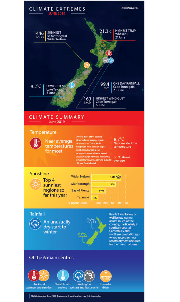
An unusually dry start to winter.
|
Temperature |
Temperatures were near average (-0.50 to +0.50°C of average) for the majority of the North Island. A portion of south Waikato observed below average temperatures (-0.51°C to -1.20°C of average) while coastal southern Hawke’s Bay and interior Manawatu-Whanganui observed above average temperatures (0.51°C to 1.2°C above average). Inland parts of Marlborough and Tasman along with northern Canterbury and West Coast experienced below average or well below temperatures (< -1.2°C below average). Temperatures were above average or well above average (>1.2°C above average) in much of Southland, coastal Otago, and a portion of interior Canterbury. Temperatures were near average for the remainder of the South Island. |
|
Rainfall |
Rainfall was below normal (50% to 79% of normal) or well below normal (<50% of normal) for the majority of New Zealand with the only exceptions being parts of lower Hawke’s Bay and Wairarapa where above normal rainfall (120-149% of normal) was observed. |
|
Soil Moisture |
As of 30 June, soil moisture levels for the time of year were near normal across most of the country with pockets of drier than normal soils in Northland, Auckland, eastern Waikato, interior Manawatu-Whanganui, coastal Wairarapa, interior Marlborough and parts of lower coastal Canterbury and northern coastal Otago. Conversely, a small area about Kaikōura observed wetter than normal soils. |
Overview
June 2019 was characterised by higher than normal mean sea level pressure. This resulted in more southwesterly winds than usual over the country. Late in the month, frequent rounds of high pressure contributed to unusually dry conditions and several rounds of colder than average morning temperatures due to clear skies, light winds, long nights, and less soil moisture than normal.
Rainfall was below or well below normal across much of the country, particularly in southern coastal Canterbury and northern coastal Otago where record or near record dryness occurred for the month of June.
With recurring high pressure systems, there were few significant weather events during the month of June. However, the month started on a stormy note as an active low pressure system brought seasonably cold temperatures, snow, strong winds, lightning and heavy rain to many areas (refer to the highlights and extreme events section for further details).
One particularly strong high pressure system (anticylone) affected the country during the final days of the month. On 29 June, a mean sea level pressure of 1043.2 hPa was recorded in Motu, Gisborne, the highest value observed in the North Island during June on record. While anticyclones do impact the New Zealand region during the winter season, this feature was rare because of its strength (>1040 hPa) and was the strongest on the planet at the time it was over New Zealand. The pattern of high pressure was contributed to by a strongly positive Southern Annular Mode and influenced by ongoing El Niño-Modoki conditions in the Pacific Ocean.
The nationwide average temperature in June 2019 was 8.7°C (0.1°C above the 1981-2010 June average from NIWA’s seven station temperature series which begins in 1909).
Further highlights
- The highest temperature was 21.3°C, observed at Whakatu on 21 June.
- The lowest temperature was -9.2°C, observed at Lake Tekapo on 3 June.
- The highest 1-day rainfall was 99.4 mm, recorded Cape Turnagain on 23 June.
- The highest wind gust was 163 km/h, observed at Cape Turnagain on 6 June.
- Of the six main centres in June 2019, Auckland was the warmest and sunniest, Christchurch was the coldest, Wellington was the wettest and least sunny and Dunedin was the driest.
- Of the available, regularly reporting sunshine observation sites, the sunniest four regions in 2019 are Wider Nelson (1446 hours), Marlborough (1429 hours), Bay of Plenty (1403 hours) and Taranaki (1380 hours).
Download
New Zealand Climate Summary June 2019 [PDF 3.3MB]
New Zealand Climate Statistics June 2019 [PDF 67KB]


