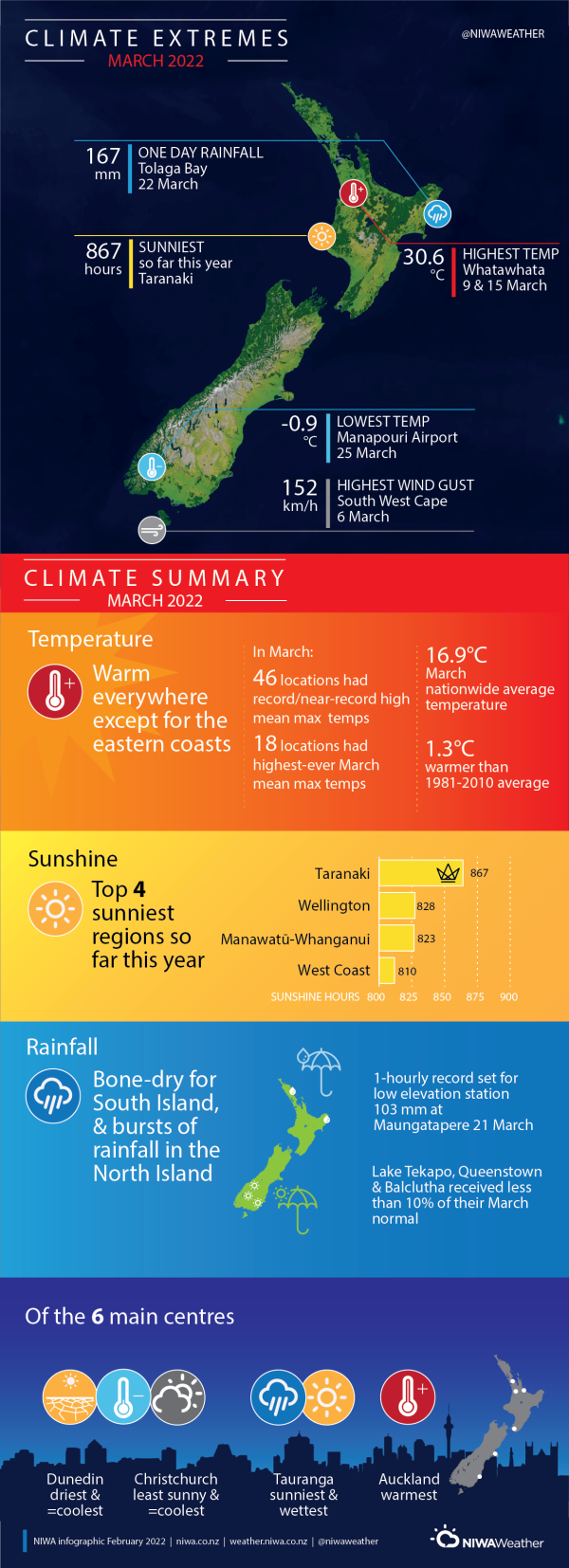
A warm and dry month for most of Aotearoa New Zealand
|
Rainfall |
Below normal rainfall (50-79% of normal) or well below normal rainfall (<50% of normal) was observed in parts of the Aupouri Peninsula, Waikato, Taranaki and Wellington, as well the vast majority of the South Island. Near normal rainfall (80-119% of normal) was observed in isolated pockets of coastal Canterbury and central and northern parts of the North Island. Above normal rainfall (120-149% of normal) or well above normal rainfall (>149% of normal) was observed across the eastern North Island and pockets of Northland and Auckland. |
|
Temperature |
Temperatures were above average (0.51-1.20°C above average) or well above average (>1.20°C above average) for most of Aotearoa New Zealand, except for areas of near average (±0.50°C of average) temperatures in the eastern North Island, parts of Wellington, parts of Marlborough, Nelson and northern Canterbury. |
|
Soil Moisture |
At the end of March, soil moisture levels were above average normal in the eastern North Island, southern Taranaki, Manawatū-Whanganui, Auckland, eastern Northland, coastal northern Canterbury and the Marlborough Sounds. Soil moisture level were below normal in western Northland, most of Waikato, northern Taranaki, and the western and southern South Island. Elsewhere, soil moisture levels were near normal. |
Overview
March was characterised by anomalously high mean sea level pressure (MSLP) over the South Island and bottom half of the North Island, leading to an easterly flow anomaly for many places, visualised in figure 1. This is consistent with the circulation patterns expected of La Niña, which lingered in the tropical Pacific. Sea surface temperatures in Aotearoa New Zealand’s coastal waters remained much higher than average during March, with marine heatwave conditions present in all regions except for the eastern North Island at the end of the month.
The result was a drier-than-normal and warmer than average month, particularly for the South Island. However, a significant heavy rainfall event occurred toward the latter part of March in the North Island, including a record-setting downpour in Northland (see Highlights and extreme events section for more details). The result was over a month’s worth of rain in less than a day or two for parts of Northland, Auckland, the Bay of Plenty and Gisborne.
March rainfall was below normal (50-79% of normal) or well below normal rainfall (<50% of normal) for the vast majority of the South Island, portions of western Northland, Waikato, northern Taranaki and Wellington. Meanwhile, above normal (120-149% of normal) or well above normal rainfall (>149% of normal) was observed across the eastern North Island and pockets of Northland and Auckland due to a burst of heavy rainfall, most of which occurred over a day or two. Otherwise, near normal rainfall (80-119% of normal) was observed in isolated pockets of coastal Canterbury, and central and northern parts of the North Island. The lack of rainfall in the lower part of the South Island led to the development of meteorological drought around Tiwai Point and about Rakiura/Stewart Island according to the New Zealand Drought Index (NZDI).
Both the flooding in Gisborne and Hawke’s Bay and the drought in the lower South Island were classified as medium-scale adverse events by the Ministry for Primary Industries (see Highlights and extreme events section for more details).
March temperatures were above average (0.51-1.20°C above average) or well above average (1.20°C above average) for most of New Zealand, except for areas of near average (±0.50°C of average) temperatures in the eastern North Island, parts of Wellington, parts of Marlborough, Nelson and northern Canterbury. There were 46 locations that observed record or near-record high mean maximum temperatures during March, with 18 locations recording their highest-ever March mean maximum temperatures. The nationwide average temperature in March 2022 was 16.9°C. This was 1.3°C above the 1981-2010 February average from NIWA’s seven station temperature series which begins in 1909, and New Zealand’s equal 8th-warmest March on record.
Further Highlights:
- The highest temperature was 30.6°C, observed at Whatawhata on 9 and 15 March.
- The lowest temperature was -0.9°C, observed at Manapouri Airport on 25 March.
- The highest 1-day rainfall was 167 mm, recorded at Tolaga Bay on 22 March.
- The highest wind gust was 152 km/h, observed at South West Cape on 6 March.
- Of the six main centres in March 2022, Tauranga was the sunniest and wettest, Auckland was the warmest, Christchurch was the cloudiest and equal coolest, and Dunedin was the driest and equal coolest.
- Of the available, regularly reporting sunshine observation sites, the sunniest four locations so far in 2022 are Taranaki (867 hours), Wellington (828 hours), Manawatū-Whanganui (823 hours), and West Coast (810 hours).
Download
- Climate Summary March 2022 (PDF 853.67 KB)
- Climate Statistics Report - March 2022 (PDF 217.44KB)


