-
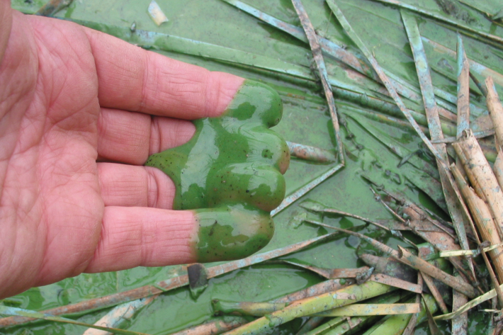
Algal monitoring service
ServiceBlooms of hazardous cyanobacteria (blue-green algae) in rivers, lakes and reservoirs can cause problems for both animal and human health. -

Aquaculture Activities
Shellfish gathering and farming take place in marine and freshwater environments. -

What is the greenhouse effect?
Education ResourceThe greenhouse effect is a warming of the earth's surface and lower atmosphere caused by substances which let the sun's energy through to the ground but impede the passage of energy from the earth back into space. -
Map I South
Education ResourceThe climate of this zone is largely dependent on the lie of the Southern Alps to the west, but many areas are also sheltered by high country to the south and east. -
Extreme weather - winds and tornadoes
Education ResourceDue to its position in the 'Roaring Forties', a belt of strong winds in the Southern Hemisphere which generally occur between the latitudes of 40 and 49 degrees, as well as its small size, New Zealand is a windy country. -

Common climate and weather terms
Education ResourceA glossary of common climate change and meteorological terms. -
Forestry activities
Forest plantations in Aotearoa can be found on flat, gently rolling, or very steep terrain. -

Publicly available data and publications
FacilityNIWA makes available and regularly updates results from several greenhouse gas measurement projects. -

UVI forecast for Specific Sites
Check out UV index forecasts for locations in New Zealand (including ski fields), Australia, the Pacific and Antarctica. -
Standardised Precipitation Index (SPI)
The Standardised Precipitation Index (SPI) is a simple measure of drought (and also of very wet conditions) and is based solely on the accumulated precipitation for a given time period.
