-

Flooding - how does it happen?
Education ResourceUnderstanding what happens above and below ground during a flooding event, and how it is different from normal rainfall conditions -
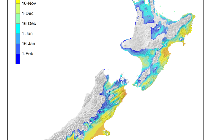
Average soil moisture deficit onset and termination maps
Maps of the average first and last dates of soil moisture deficit are shown here. -

Generating synthetic wind data
Research ProjectNIWA has recently created synthetic, multi-year, 10-minute wind datasets at 15 wind farm sites across New Zealand. These will be used by the Electricity Commission to model the impact of wind farms on the national grid. -

Climate and weather
Information about climate and weather and links to climate-related websites. -
Tuna - customary fisheries
Māori have an extensive knowledge of the ecology of freshwater eels, and have maintained their customary fisheries for several centuries. -

Loss of riparian vegetation
Plants and trees along the water margins and banks are called riparian vegetation. -
Cloud Imagery
On this page
NZ Region Cloud Analysis Australasian Region Infrared Hemispheric Infrared NZ High-res Visible Contact
All transmissions from GMS-5 are no longer received at NIWA’s satellite reception station in Wellington. We are working on an alternative data feed and will be able to bring back these images later this year. Once we start receiving data again, it will then be calibrated, re-mapped onto standard map projections, and archived. -
Trawl fisheries bycatch
Accurate reporting on the amount of fish and invertebrates that are caught and discarded by New Zealand’s commercial fishing industry is vital to effective management of these fisheries. -

Dry stock farming activities
Dry stock farms can cover large areas of hill-country grassland that may be steep and prone to erosion. -

Understanding and predicting floods and their impacts
Feature story06 June 2017Floods are not unusual in New Zealand, but those that hit us early this winter broke records. Why did they occur? Should we expect more? Can we predict future floods?