
Drought forecasting dashboard
NIWA and MPI are working together to develop a new drought forecasting tool. It uses innovative climate modelling, the latest in machine learning and other data-driven techniques to predict rainfall 35 days ahead. It will help farmers and growers better prepare for periods of dryness and drought.
Climate and weather
-

Regional modelling of New Zealand climate
Research ProjectDeveloping probabilistic scenarios of expected future regional climate changes. -

NZ Drought indicator products and information
Drought is a common feature of New Zealand's climate. On average, every year or two somewhere in New Zealand experiences a drought. -

Southwest Pacific Tropical Cyclone Outlook
Publication seriesA summary of up-coming tropical cyclone seasons, issued 6-monthly. -
Map C North
Education ResourceAs this region is sheltered by high country to the south and east, it has less wind than many other parts of New Zealand. -
What is ocean acidification?
Education ResourceOcean acidification is the name given to the lowering of pH of the oceans as a result of increasing carbon dioxide (CO2) in the atmosphere. -
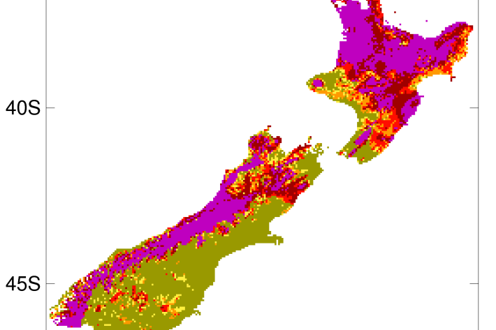
2012-2013 Drought
The 2012-2013 drought affected the entire North Island plus the west coast of the South Island. -

Canterbury
All aspects of the climate of Canterbury are dominated by the influence of the Southern Alps on the prevailing westerly airflows. -

Manawatu-Wanganui
The climate of the Manawatu-Wanganui region is a reflection of the generally disturbed westerly air flow with interspersed anticyclones, modified in specific places by the local topography. -
Mean number of days of ground frost
These datasets are available in a range of formats. -
NIWA staff profile: Nava Fedaeff
Feature story06 June 2017At the age of seven, NIWA’s youngest climate scientist, Nava Fedaeff, swapped sub-arctic Siberia for balmy Auckland – and her first job was to learn to swim. -
Map Chatham
Education ResourceExtremes of temperature are rare as the Chatham Islands are small land masses surrounded by sea.