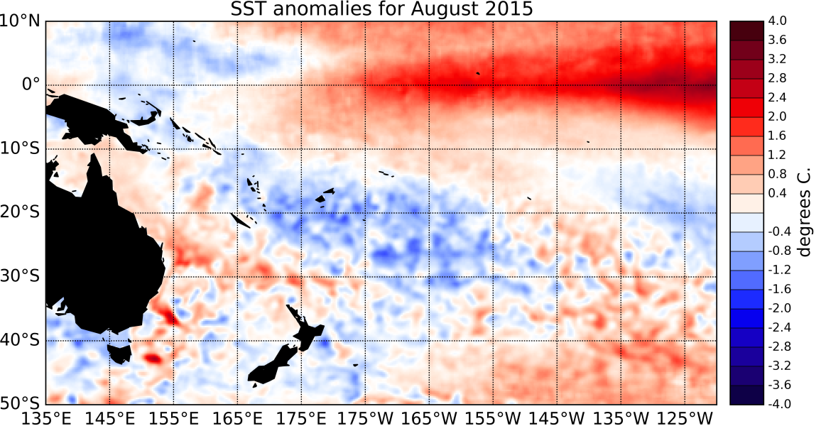
El Niño conditions strengthened further during August 2015 and reached the strong El Niño category. The Southern Oscillation Index (SOI) has also remained strongly negative and is at -2.0 for August 2015 as a whole (preliminary value).
Westerly wind anomalies (weaker trade-winds) currently dominate the central and western equatorial Pacific, and convection has shifted east of the Dateline, indicating a strong coupling between the ocean and the atmosphere. The South Pacific Convergence Zone (SPCZ) appeared to have been mostly suppressed in the southwest Pacific.
The ENSO Precipitation Index (ESPI) reflects strong El Niño conditions with a value of +2.15 (value to the 2nd of September). SST anomalies have continued to increase in the eastern and central Pacific in August 2015 with SST anomalies in both the NINO3.4 and the NINO3 indices now close to +2°C. (+1.81°C and +1.94°C above normal respectively). The NINO4 index (in the western Pacific) remains stable at +1.08°C. Sub-surface ocean temperature anomalies in the eastern Pacific have increased dramatically in the past few weeks and reach +7°C between ~ 50 and 100m depth east of ~ 120°W. Heat content anomalies (top 300m of the ocean) also intensified considerably during August and exceed +2.5°C between 140 and 120°W. These sub-surface anomalies have the potential to sustain and support a further increase of the strong surface anomalies.
The Madden-Julian Oscillation (MJO) was mostly inactive over the western Pacific during the past two weeks. At the forecast horizon of 14 days, both the dynamical and statistical CPC forecasts indicate very weak amplitudes of the MJO, accompanied with slightly reduced intra-seasonal convective activity in the western Pacific. International guidance indicates that El Niño conditions are certain (100% chance) to continue over the next three month period (September – November 2015) and virtually certain (99% chance) to carry on into the summer (December 2015 – February 2016).

