At NIWA we combine capabilities in weather, storm surge, wave and tide forecasting with tide gauge observations to predict sea levels for specific locations under forecast weather conditions. This capability is underpinned by our NIWA Forecast software.
Storm surge and wave forecasts can alert you when sea levels pass a certain threshold, enabling you and your community to take steps to prepare for potential inundation.
If you’d like to talk about these services for your location, get in touch using the contact details below.
How does NIWA forecast waves?
Ocean waves are simulated/predicted using spectral models. NIWA has developed an operational wave forecast system based on a wave model called Wave Watch III, which is run using our multi-hazard system forecast system. NIWA’s wave models increase in resolution towards mainland New Zealand, which on three domains: GLOBALWAVE (17 km), NZWAVE (4 km) and NZWAVE-HR (2 km).
The wave models accommodate the processes of wind generation, white-capping and bottom friction, and include a direct estimate of non-linear energy transfer through four-wave interactions. The highest resolution model includes water level and currents from tides and storm surge. The inclusion of these processes is important because changes in water level modify the depth in which the waves will propagate. In addition, opposing currents can steepen waves.
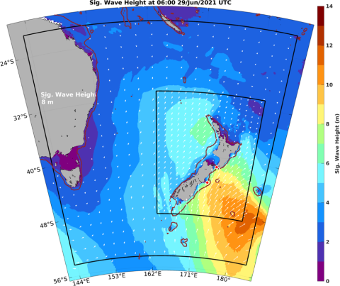
The image below shows the complex pattern of significant wave height and wave direction around New Zealand on a particular day. Wave heights vary considerably over even a short period. To describe waves, engineers and scientists use a statistic called the significant wave height, which is the average wave height of the highest third of waves in a sea – or those which cause more damage or difficulty.

The image above shows NIWA’s wave forecast domains and wave height in the Southwest Pacific at 6UTC June 29, 2021 (as an example). Significant wave height (m) is shown as a rainbow shade (warm colours = larger waves), while arrows in every 40th grid cell of each model domain show wave direction, with their length proportional to wave height. In this simulation the model uses input wind data sourced from our NZLAM and NZCSM weather forecast models.
How does NIWA forecast storm surge?
Our storm surge forecasts use local tide gauge observations to provide a forecast relative to a fixed datum or by mean sea level anomaly.
Tide gauge data needs to be ingested into our system at near real time to be used – we currently do this for these sites. If you’re interested in installing a sea-level gauge or providing access to data from an existing gauge, get in touch.
If there is no tide gauge at a location of interest, we can infer the mean sea level anomaly from nearby sites, although these may be less accurate.
We can also use data from existing LINZ/GNS tsunami gauges although these use pressure gauges for measurements and can drift over time.
Case study: Sumner, Christchurch
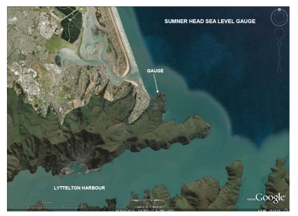
NIWA currently provides a storm surge forecast service at Sumner Head for Christchurch City Council.

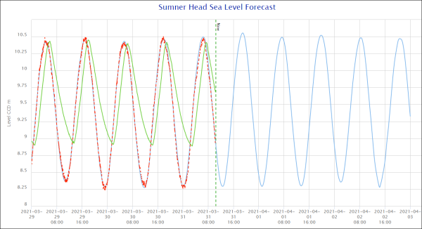
In the forecast image below:
- The blue line shows the forecast sea level
- The red dotted line shows observed sea level (as these observations become available).
- The vertical dotted line indicates the point in time at which the screenshot was taken.
- The green line shows observational data for Bridge Street, New Brighton (as a comparison.) Note that the amplitude of this curve is reduced and timing slightly delayed compared with the Sumner values due to effects from the estuary. These estuarine effects also cause the nonlinearity of the signal (saw tooth shape with steeper increase and slower ebb). The higher baseline for Bridge Street is due to the river input.


