-

The impact of El Niño and La Niña on New Zealand's climate
El Niño accounts for less than 25 percent of the year-to year variance in seasonal rainfall and temperature at most locations in New Zealand. -
NZ's warmest and wettest winter on record
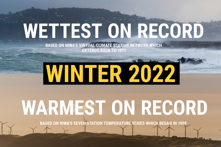
Media release06 June 2017NIWA’s climate scientists can now confirm what you may have suspected. After carefully poring through more than a century’s worth of data, it has been officially determined that winter 2022 was Aotearoa New Zealand’s warmest and wettest on record. -

Island Climate Update
Publication seriesA monthly summary of the climate in the tropical South Pacific islands, with an outlook for the coming months. -

New map reveals New Zealand’s seafloor in stunning detail
News article06 June 2017 -

West Coast
West Coast is New Zealand’s wettest region, and this may be attributed to its exposure to the predominant westerly airflow over the country, combined with the orographic effect of the Southern Alps. -
What are whitebait?
Whitebait are the juveniles of five species of galaxiidae, a family of fish confined to the Southern Hemisphere. -

Aquaculture Activities
Shellfish gathering and farming take place in marine and freshwater environments. -
Map I South
Education ResourceThe climate of this zone is largely dependent on the lie of the Southern Alps to the west, but many areas are also sheltered by high country to the south and east. -
Extreme weather - winds and tornadoes
Education ResourceDue to its position in the 'Roaring Forties', a belt of strong winds in the Southern Hemisphere which generally occur between the latitudes of 40 and 49 degrees, as well as its small size, New Zealand is a windy country. -
Scientists set to delve into the secrets of the Cook Strait mega-canyon
News article06 June 2017