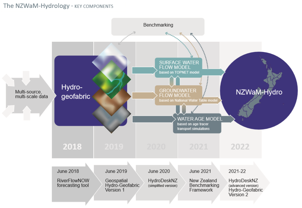
The purpose of the Hydro-Geofabric task within the NZWaM-Hydro project is to gather, harmonise and enhance existing multi-source spatial datasets to form a framework tailored for hydrological modelling.
This geo-spatial database forms the backbone of the NZWaM-Hydro project. It is a specialised Geographic Information System (GIS) providing core information for managing New Zealand’s water resources within a single, consistent, integrated, national geospatial framework. The Hydro-Geofabric registers the spatial relationships (between important hydrological features such as soil, land cover, rivers, water-bodies, aquifers and monitoring locations across Aotearoa. This complex task is achieved by identifying the finest level of detail where coarse-scale assumptions of hydrological connectivity can be usefully applied to identify hydrological features.
The Hydro-Geofabric is conceptually similar to the US National Hydrography Dataset Plus (NHD Plus). Like NHD Plus it contains national surface water hydrology layers and monitoring sites within a network topology, which is linked to a high resolution national Digital Elevation Model (DEM), and derived catchments and associated reporting units (such as catchment boundaries, Freshwater Management Units (FMU), and regional boundaries). The Hydro-Geofabric also contains a national groundwater hydrology layer as well as surface water-groundwater isotope layer enabling the representation of appropriate landscape hydrological processes to correctly simulate the transfer of water and pollutants from sources to receiving water bodies. As a result, the Hydro-Geofabric is developed using time varying datasets such as:
- raw spatial and temporal hydro-geological data e.g. river networks, soils, geology, land use, climate; and
- derived spatial and temporal hydrological parameters e.g. soil moisture content at saturation, hydraulic conductivity at surface and for different hydro-geological layers.

Who and what is involved
The Hydro-Geofabric is co-developed by NIWA with Manaaki Whenua – Landcare Research and GNS Science and provides the underpinning architecture of NZWaM-hydro. The partnership provides a collaborative mechanism for obtaining up to date hydrological data and a mechanism to upgrade this data through an enduring maintenance framework. The framework is initially be based on a simple conceptual model that will evolve over time to include increasingly sophisticated elements.
As part of this task, geospatial data is acquired from Regional Councils, LAWA, Crown Research Institutes, Land Resource Inventory, the NIWA Climate Database, various remote-sensing platforms, and via collaboration with industrial sectors.
The Hydro-geofabric has a six year life-span and will deliver products in two phases. The Hydro-Geofabric will be run and maintained using NIWA’s High Performance Computing Facility.
Progress to date
As part of the Hydro-Geofabric the following developments have been achieved:
2020 - 2021
- A draft technical guidance manual for the Hydro-Geofabric, with description of the delineation processes completed.
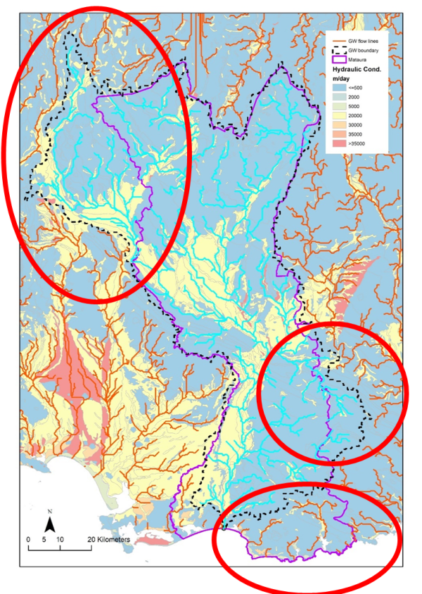
- Development of a simple methodology (based on existing data) to generate the locations of groundwater catchments that discharge to surface river network. This is illustrated in Figure 2 where the outline of the surface water and groundwater catchments (associated with the Mataura Freshwater Management Units in Southland) are represented by the purple line, and dashed line respectively. Areas where surface water catchment does not match groundwater catchment are circled in red.
2019 - 2020
- Ingestion of the hydro-geofabric as part of HydroDesk NZ for DN1 and DN2;
- Annual update of streamflow hydrological observations implemented in surface water catchment layer.
2018 - 2019
Development of the surface water component of the Hydro-geofabric across the three versions of the digital river network. This includes:
- Surface water catchment delineation completed across the three digital network versions.
- Land cover maps (available for 2008-2012 and 2016); soil information (Fundamental Soil Layer and S-map); and Geological map (QMap) layers; added to the Hydro-geofabric framework.
- National scale groundwater layers (i.e. long-term average depth to groundwater, depth to the geological basement and effective porosity parameters) added to the framework.
- Annual update of streamflow hydrological observations implemented in surface water catchment layer.
2017 - 2018
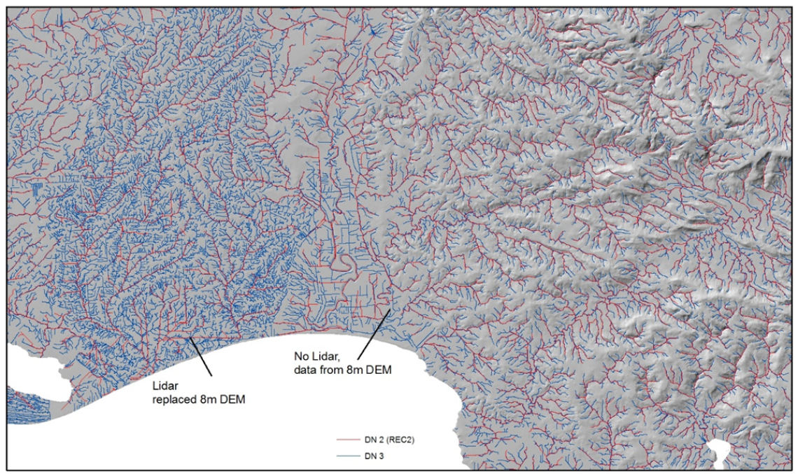
Development of the Digital River Network version 3.1 (peer reviewed by all regional councils). This new network is the result of the development of a new hybrid high resolution national digital elevation model combining existing Lidar information with national scale 8m digital elevation model (Geographix).
The new network enables a seven-fold increase of the spatial resolution at which spatial information is available compared with version 1 (2008) and version 2.5 (2020). Figure 1 presents the difference in spatial resolution between DN2.5 (red lines) and DN3.1 (blue lines) for the Waituna catchment in Southland.
This map shows a comparison of the existing REC-DN 2 (red) and new REC-DN 3 (blue) digital stream networks for the Waituna catchment in Southland. LiDaR information has significantly improved the spatial definition of the network. [Source: NIWA]

The project is funded through the Strategic Science Investment Fund from the Ministry of Business, Innovation and Employment.


