-
New ocean data from under the world’s biggest ice shelf
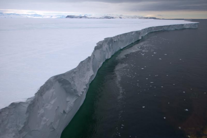
Media release30 June 2020New measurements from the ocean under the centre of the Ross Ice Shelf have significantly improved our understanding of the complex processes that drive melting in Antarctica. -

Glaciers continue to melt away
Media release24 June 2020Scientists analysing end-of-summer snowline survey photos have estimated that 13 million cubic meters of ice have been lost from just one glacier from 2016 to 2019. -

Regional Projections: Zone 7
Zone 7: Chatham Islands (Wharekauri – Rēkohu) and Pitt Island (Rangiauria –Rangiaotea) at longitude 183–184˚E. -
Regional Projections: Zone 6
Western and southern South Island (Te Wai Pounamu) – covers the West Coast, Fiordland, Southland and Stewart Island (Te Punga o Te Waka ā Māui) and includes the Southern Alps and southern lakes. Includes Canterbury and Otago. -
Regional Projections: Zone 5
Zone 5: Eastern South Island (Te Wai Pounamu) from Kaikōura to Owaka (South Otago) and includes Central Otago and the MacKenzie Basin including Lakes Tekapo to Ōhau to the east of the Southern Alps. Includes the West Coast, inland Otago and Southland. -
Regional Projections: Zone 4
Northern South Island (Te Wai Pounamu) – covers Marlborough (from Kaikōura north), Nelson (Whakatū) and around to Punakaiki on the West Coast. Includes Tasman, Nelson, Marlborough and Buller District. -
Regional Projections: Zone 3
Eastern lower North Island extends from Hicks Bayto Palliser Bay and back to the Ruahine and Kaweka ranges. Includes Gisborne, Hawke’s Bay and the Wairarapa catchment of Wellington. -
Regional Projections: Zone 2
Zone 2: Western lower North Island (Te Ika ā Māui) – covers Taranaki to Wellington (Te Whanga-nui-a-Tara) and includes National Park and southern Lake Taupō. Includes the regions of Taranaki, Manawatū–Whanganui (Horizons) and Wellington. -
Regional Projections: Zone 1
Upper North Island (Te Ika ā Māui) – extends to Mōkau on the west coast and Lottin Point (Wakatiri) in eastern Bay of Plenty, and the northern part of Lake Taupō. -

National Climate Change Risk Assessment
The NCCRA assessment was commissioned by the Ministry for the Environment and has identified the most significant risks we face from climate change. It will feed into the Government’s national adaptation plan. -

Scientists nurturing only plant of its kind
Media release11 June 2020For more than 20 years NIWA scientists have been nurturing three plants that are the only examples of their kind in existence.
