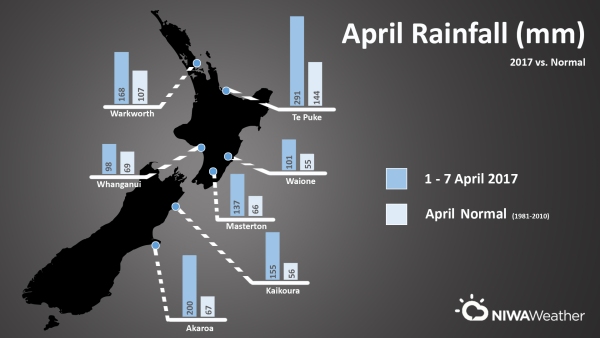
The Tropical Torrent that spread over New Zealand this week, produced up to three times the normal April rainfall for some locations in three days, NIWA forecaster Ben Noll says.
Mr Noll said, deep tropical moisture was siphoned southward towards New Zealand by remnant energy from ex-Tropical Cyclone Debbie forming an atmospheric river. Atmospheric rivers are relatively long, narrow regions in the atmosphere—like rivers in the sky—that transport most of the water vapour outside of the tropics.
Research indicates that for New Zealand, atmospheric rivers occur about 40 days per year and are associated with about half (48%) of the country’s rainfall extremes.
An atmospheric river was also a key component of the Tasman Tempest during early March.
The numbers
- Auckland (Mangere) recorded exactly its normal April rainfall (84.6 mm) in just 14 hours between Tuesday evening and Wednesday morning. With 481 mm of rain year-to-date (through 7 April), Auckland (Mangere) is off to its wettest start to any calendar year on record (since 1959).
- After recording 121 mm of rain from the Tropical Torrent, Hamilton is off to its second wettest start to any calendar year on record (since 1907) with 537 mm of rain.
- The torrent brought 164 mm of rain to Tauranga or 135% of the April normal.
- Whakatane had its wettest April day on record (since 1952) on the 4th with 137 mm of rain. Total rainfall from the Torrent was 209 mm.
- Whangaparaoa, north of Auckland, observed 172 mm of rain between 9.00 am 4 April and 9.00 am 5 April, or 2.4 times the normal April rainfall in just 24 hours. Storm total rainfall from the Torrent was 198 mm. The Peninsula has received 670 mm of rain since the start of the rain and is off to the wettest start to any calendar year on record (since 1946) by a rather remarkable 206 mm.
- After recording 76 mm of rain from the Torrent, Kaitaia is off to its second wettest start to any calendar year on record (since 1948) with 567 mm.
- Whitianga on the Coromandel Peninsula observed 150 mm of rain on the 4th, good for the wettest April day on record (since 1961).
- Te Puke in the Western Bay of Plenty was one of the Torrent’s wettest locations, recording 290 mm. This is 2 times the normal April rainfall in just 4 days.
- Wellington (Airport) recorded 72 mm in one day between 9.00 am Wednesday and 9.00 am Thursday, making it the wettest day at the airport in about 9 years, or since April 30-May 1, 2008.
- Kaikoura observed 155 mm of rain from the Torrent, or 2.8 times the normal rainfall for the entire month of April.
- Akaroa on Banks Peninsula recorded 200 mm from the Torrent, or very nearly 3 times the normal rainfall for all of April.
Next week
New Zealand is stuck in a pattern that favours strong low pressure systems to the west of the country and sweeping high pressure systems to the south and east - basically a meteorological traffic jam, Mr Noll says.
Such a setup favours sub-tropical or tropical northerly winds and was present during both the Tasman Tempest and Tropical Torrent and looks to repeat itself once again next week. This may result in another round of heavy rain from about late Tuesday for the North Island and north and east of the South Island.
Furthermore, a tropical disturbance north of Vanuatu is being monitored for strengthening over the weekend into early next week. There is some uncertainty regarding the eventual strength and track of the tropical system, although its progress will need to be watched closely as it could influence New Zealand’s weather later next week.
Sub-seasonal climate models that are monitored by NIWA indicate a persistence of the active weather into late April.

