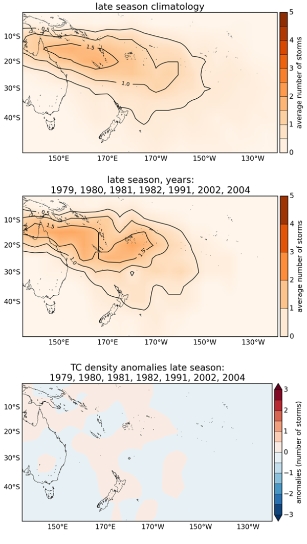
This update for the latter half of the 2016–17 Tropical Cyclone (TC) season (February to April 2017) suggests near normal activity can still be expected.
The 30-year (1981-2010) average number of all (named) storms is 12.4 (10.4) in the Southwest Pacific (between 135°E - mid-Gulf of Carpentaria, and 120°W - French Polynesia) each season for November to April. So far, no named storms have occurred in the Southwest Pacific basin, making it one of the quietest seasons on record. The updated outlook indicates that, from an analysis of past analogue seasons, approximately six named storms could be expected from this time. If that outcome eventuates, the full season total for 2016–17 season would be six named storms, which is less than what normally occurs for an entire TC season. Changes from previous guidance (issued in October 2016) indicate TC activity is likely to be near normal for most of the basin for the remainder of the TC season.
This updated outlook for the second half of the TC season reflects recent conditions in the equatorial Pacific Ocean with respect to El Niño Southern Oscillation (ENSO). In October, we expected that a weak La Niña might develop during November and exist through at least January. That did not occur. However, the TC outlook for the islands of New Caledonia, Vanuatu, Fiji, and Tonga still indicates two or more cyclones could interact with each of these countries during the late season. Past seasons that had conditions similar to those presently in place suggest the possibility that more than one severe TC (Category 3 or higher - see definition of categories) could occur. As a result, all communities should remain vigilant and follow forecast information provided by their national meteorological service. As a reminder, all TCs present hazards, regardless of size and intensity, and vigilance when a TC warning is issued is always a prudent course of action.
On average, New Zealand experiences at least one ex-tropical cyclone passing within 550km of the country every year. If an ex-tropical cyclone comes close to the country, the current background climate conditions suggest it may pass either east or west of Auckland city.
Outlook analysis
Near neutral ENSO conditions are currently indicated by sea surface temperature anomalies across the central and eastern Equatorial Pacific Ocean. In addition the regional atmospheric circulation pattern, the climate state is also relatively weak in the southwest Pacific, and South Pacific Convergence Zone organization in months past has been weak. There is an expectation amongst a number of international forecast centres that neutral ENSO conditions will continue in coming months. Consequently, near normal TC activity is anticipated for many islands in the Southwest Pacific during the remainder of the 2016–17 season, with an additional 6 named storms expected to form.
Southwest Pacific TCs are grouped into classes ranging from 1 to 5, with 5 being the most intense. For the remainder of the TC season, there is a distinct possibility that at least two storms may reach at least Category 3 status; these storms have maximum sustained wind (MSW) speeds of at least 64 knots or 118 km/h. Of those systems, one storm may reach at least Category 4 strength, with MSW speeds of at least 86 knots or 159 km/h. Category 5 strength TCs (MSWs greater than 106 knots or 196 km/h) have not occurred during seasons that had conditions similar to present, so this type of event is considered unlikely. Therefore, all communities should remain alert and well-prepared for severe events.
Tropical cyclones have a significant impact across the Southwest Pacific from year to year. Vanuatu and New Caledonia typically experience the greatest activity, with an average of two or three TCs passing close to land each year. For the remainder of the season, the outlook indicates near normal TC activity for many islands.
On average, New Zealand usually experiences at least one interaction per season with an ex-tropical cyclone during ENSO neutral conditions. Two of the seven analog seasons identified for this forecast update do not show an ex-tropical cyclone coming close (within 550 km) to the country, however there are a couple of analog that suggest an ex-tropical cyclone interaction is still possible. Seasonal climate forecast information recently issued by the National Climate Centre about expected regional atmospheric pressure patterns for February–April suggest a weakening system could still be steered toward New Zealand. While anomalous high pressure systems are favoured to the north of New Zealand through April, the Madden-Julian Oscillation (MJO), or tropical disturbances that propagate eastward around the global tropics, may disrupt this pattern for periods of time. During which an ex-tropical cyclone may be more likely to form and impact New Zealand. These types of systems can generate damaging wind, waves and severe rainfall even if they do not make landfall. Impacts can also be spread over a larger area when interacting with a ‘high’ pressure system.
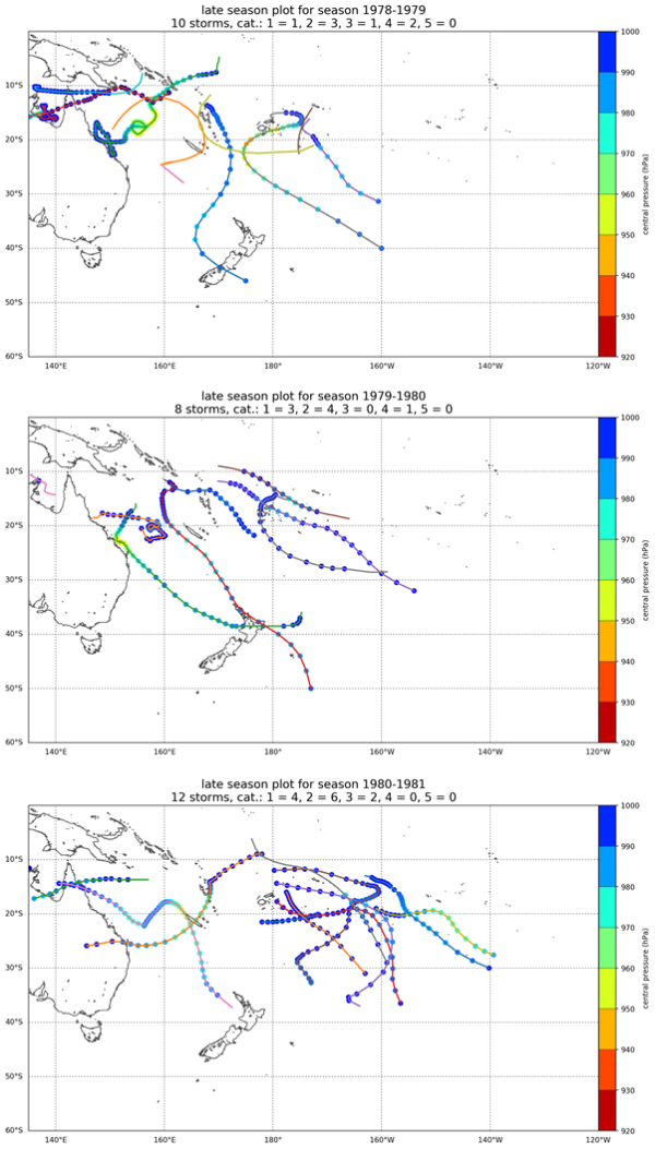
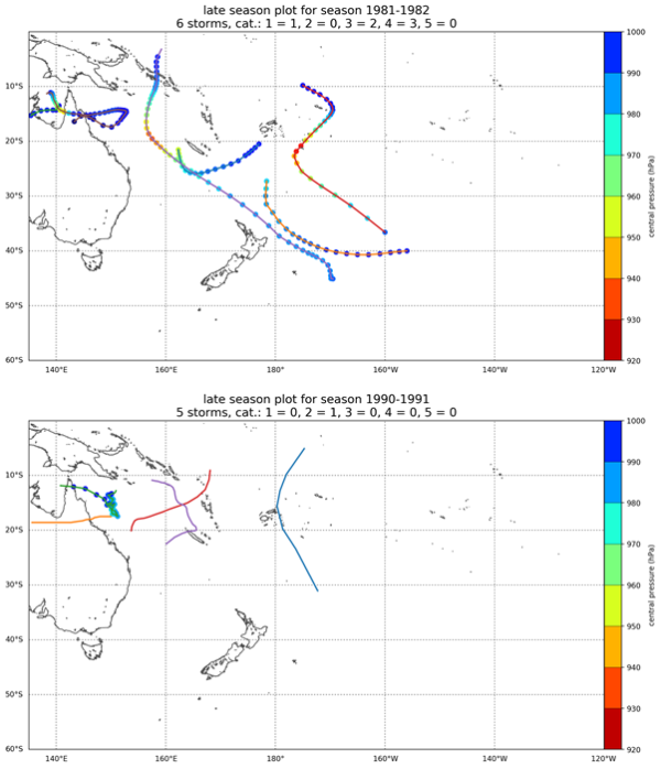
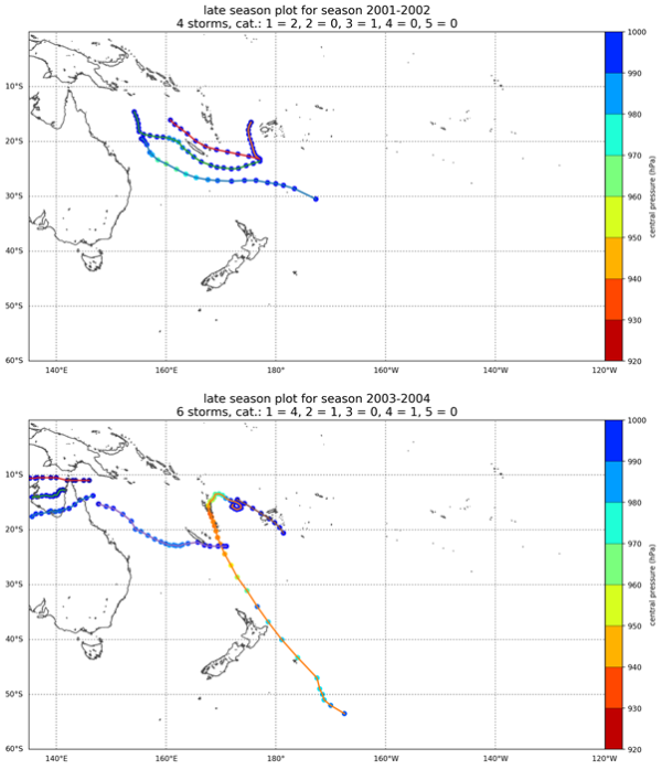
Even though TC activity is expected to be near normal for the remainder of the season, historical cyclone tracks (see supporting information for this forecast, Figure 2) indicate that TCs can affect parts of French Polynesia (including the Society Islands and the Austral Islands). As with the majority of other years, the late TC season (February–April) is still expected to be the most active time in the Southwest Pacific.
All Pacific Islands should remain vigilant in case equatorial Pacific conditions change during the TC season. Past seasons with conditions similar to present have seen TC tracks with increased sinuosity (irregular or looping motions rather than a curvilinear trajectory), which means they have potential to linger and impact a large area.
New Zealand’s National Institute of Water & Atmospheric Research (NIWA) along with meteorological forecasting organizations from the Southwest Pacific, including the Australian Bureau of Meteorology, and the Pacific Island National Meteorological Services, have contributed to this tropical cyclone outlook.
Contacts
In New Zealand:
Mr. Chris Brandolino - Meteorologist, NIWA
Mr. Ben Noll - Forecaster, NIWA
Dr Andrew Lorrey - Climate Scientist, NIWA
Dr Nicolas Fauchereau - Climate Scientist, NIWA
In the Pacific Islands, please contact your local national meteorological service for information about how this guidance should be interpreted.
For Australia and associated offshore islands, please contact the Australian Bureau of Meteorology for information about how this guidance should be interpreted.
For French Polynesia and New Caledonia, please contact MeteoFrance for information about how this guidance should be interpreted.
Background information and figures
Table 1: Analog seasons and intensity of TCs and storms that occurred in the Southwest Pacific for updated analogs – including late season storm counts.
|
Late Season |
Number of named storms |
Right: TC category (BoM scale) |
Cat 1 |
Cat 2 |
Cat 3 |
Cat 4 |
Cat 5 |
|
|
1978/79 |
7 |
1 |
3 |
1 |
2 |
0 |
||
|
1979/80 |
8 |
3 |
4 |
0 |
1 |
0 |
||
|
1980/81 |
12 |
4 |
6 |
2 |
0 |
0 |
||
|
1981/82 |
6 |
1 |
0 |
2 |
3 |
0 |
||
|
1990/91 |
1 |
0 |
1 |
0 |
0 |
0 |
||
|
2001/02 |
3 |
2 |
0 |
1 |
0 |
0 |
||
|
2003/04 |
6 |
4 |
1 |
0 |
1 |
0 |
||
|
Mean total |
6.1 |
2.1 |
2.1 |
0.9 |
1 |
0 |
||
|
Rounded mean total |
6 |
2 |
2 |
1 |
1 |
0 |
Analog guidance summary (Update):
The initial outlook of 8-10 named TCs that were expected for the 2016-17 season for the Southwest Pacific basin (135° E – 120° W) is downgraded in this outlook update, with a mean of 6 implied by the selected analogs based on what could occur during the late season (February-April). Despite the lack of tropical cyclone activity during the first half of the season, the outlook from February to April is for near normal activity. Considering the season as a whole, below normal activity is expected.
For the remainder of the season, two cyclones may reach category 3 or higher. The long term TC climatology (last 46 seasons) suggests the occurrence of a Category 5 system during the late season can occur; however no analogs in our update indicate that is likely.
Normal likelihood of an interaction for New Zealand (at least one storm coming within 550km of the country) exists for the remainder of the 2016-17 season. Historic track data indicate ex-tropical cyclones can pass either east or west of Auckland during conditions similar to present.
Figure 2: Plots of TC tracks and major storms that were monitored for analog seasons used in the 2016-17 seasonal forecast for the full season (November - April). [Track data are courtesy of the South Pacific Enhanced Archive for TC research (SPEArTC)]


