A weekly update describing soil moisture across the country to help assess whether severely to extremely dry conditions are occurring or imminent. Regions experiencing these soil moisture deficits are deemed “hotspots”. Persistent hotspot regions have the potential to develop into drought.
Please note that this will be the final Hotspot Watch issued by NIWA for the 2016-2017 growing season. Hotspot Watches will again be issued beginning in October 2017.
Facts: soil moisture
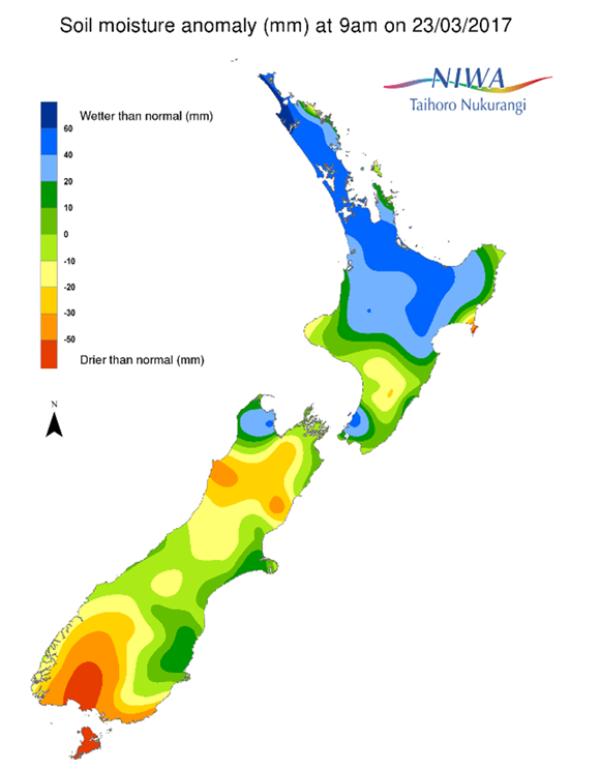
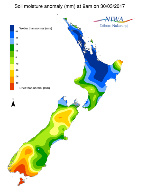
Across the North Island, soil moisture levels have increased nearly everywhere during the past week. This is especially true across Northland, Auckland, Waikato, and the western Bay of Plenty where heavy rain fell earlier this week.Smaller increases also occurred across most of the remainder of the North Island, with only small decreases in soil moisture levels observed in East Cape during the past week. The driest soils across the North Island compared to normal for this time of the year are found in East Cape, while the wettest soils for this time of the year are found across southern Northland, Auckland, northern Waikato, and the western Bay of Plenty.
No hotspots are currently in place across the North Island.
Across the South Island, soil moisture levels have increased slightly in many areas during the past week. This was most evident across the northern half of the South Island. Meanwhile, soil moisture levels generally decreased slightly across Southland and the Queenstown-Lakes District in the past week. The driest soils across the South Island compared to normal for this time of the year are found in southern Southland, while the wettest soils for this time of the year are found in northwestern Tasman.
Hotspots are currently in place in southern Southland and central Queenstown-Lakes District, along with a small hotspot located in central Hurunui District.
Outlook and soil moisture
For the North Island, high pressure is expected to produce dry weather on Friday and Saturday. On Sunday (2nd April), a few showers in northern and central areas may produce rainfall amounts of 5 mm or less. By Monday and Tuesday, tropical moisture related to former Cyclone Debbie will begin to stream in from the Tasman Sea. Rainfall amounts during this time could reach 50 mm in parts of the western and central North Island. Additional heavy rain may track across the North Island on Wednesday (5th April) and Thursday as well. While the exact track of this tropical moisture will be vital to determining where the heaviest rainfall occurs, totals through to next Thursday could exceed 75 mm in the western and central North Island, with 50 mm or more possible elsewhere.
With heavy rainfall possible in much if not all of the North Island during the next week, soil moisture levels are expected to increase nearly everywhere. Because of this, no hotspots are expected to form.
For the South Island, moist air streaming from the Tasman Sea on Friday and Saturday will bring up to 50 mm to Fiordland and southern Westland, while mostly dry weather is expected elsewhere. Up to 15 mm is possible along the rest of the West Coast on Sunday (2nd April). Mostly dry weather is expected from Monday until Tuesday evening as high pressure moves over the South Island. However, the same tropical moisture expected to affect the North Island will likely also track across the northern half of the South Island between Wednesday and Thursday (5th-6th April). From the West Coast to Tasman, rainfall amounts may exceed 75 mm, with 50 mm or more possible across Canterbury, Marlborough and Nelson. Amounts around 25 mm will be possible in Otago and much of Southland.
Heavy rainfall next week may increase soil moisture levels substantially across the northern half of the South Island, with the small hotspot in Hurunui District likely to dissipate. Soil moisture levels will also increase in Fiordland, with more moderate increases possible in southwestern Southland. Meanwhile, across most of Otago and eastern Southland, soil moisture levels may remain about the same or increase slightly. This may lead to some improvement to the hotspots in southern Southland and central Queenstown-Lakes District.
NIWA recently introduced a new tool to monitor drought conditions across New Zealand called the New Zealand Drought Index (NZDI).
Background
Hotspot Watch a weekly advisory service for New Zealand media. It provides soil moisture and precipitation measurements around the country to help assess whether extremely dry conditions are imminent.
Soil moisture deficit: the amount of water needed to bring the soil moisture content back to field capacity, which is the maximum amount of water the soil can hold.
Soil moisture anomaly: the difference between the historical normal soil moisture deficit (or surplus) for a given time of year and actual soil moisture deficits.
Definitions: “Extremely” and “severely” dry soils are based on a combination of the current soil moisture status and the difference from normal soil moisture (see soil moisture maps).
The following soil moisture anomaly maps, are relative to this time of year. The maps show soil moisture anomaly for the past two weeks.


