Weekly update to help media assess likelihood of extremely dry weather preceding a drought. Regions experiencing severely to extremely drier than normal soil conditions are deemed “hotspots”.
Facts: Soil Moisture
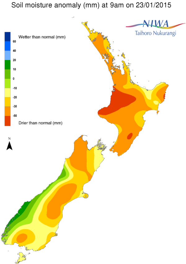
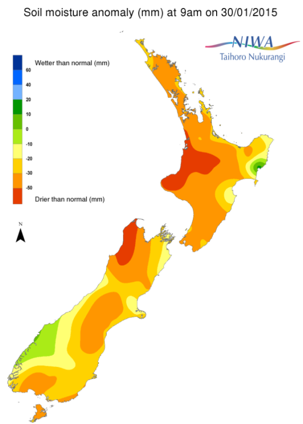
For the North Island, severely to extremely drier than normal soils for this time of year continue for the vast majority of the island. Exceptions include south-coastal Gisborne, parts of Hawke’s Bay, isolated pockets of the Bay of Plenty and Waikato regions as well as along the western slopes of the central and northern Tararuas.
For the South Island, severely to extremely drier than normal soil moisture levels for this time of year exist for most of the island along and east of the Divide, including central and eastern Southland, much of the Tasman, Nelson an Marlborough regions. Additionally, much drier than normal soils for this time of year exist over southern Southland, near and just northwest of Invercargill.
Week-to-Week Comparison
When compared to this time last week widespread dryness continues to cover the majority of New Zealand. For the North Island, the only pronounced change, as alluded to last week, was an increase in soil moisture levels for parts of the southeast coast of the island from Gisborne to Hawke’s Bay. In fact, a significant increase in soil moisture levels has occurred, albeit localised, over south-coastal Gisborne. However, on the other end of the spectrum, soils have continued to dry for the coastal Bay of Plenty and eastern Waikato regions.
For the South Island, the slight-to-modest soil moisture gains that were noted last week in parts of central and southern Otago have been negated as the lack of rain has lowered soil moisture levels there to less than this time last week. Also, soil moisture levels have continued to diminish over central and eastern Southland as well as far northern parts of the West Coast, Tasman, Nelson and Marlborough regions.
Commentary
For the North Island, when considering the current soil moisture anomalies for this time of year, the overwhelming majority of the island is more-or-less one large hotspot. Exceptions to this are the most of the Gisborne, parts of the Hawke’s Bay, as well as pockets of the Taranaki, Manawatu-Wanganui and Wellington regions.
Computer models are indicating the distinct possibility for a significant rainfall event later this weekend into early next week for central and western parts of the North Island along with the possibility of more meaningful rainfall later in the week. Naturally, it’s too early to provide exact details, but suffice it to say that moderate to significant relief is possible for some hotspot areas of the island over the coming days. Other areas of the island are likely to receive at least some rainfall, however, it’s less likely (though not impossible) that a significant increase in moisture soils will result.
For the South Island, hotspots exist throughout much of Otago, parts of Southland and most of the island located along and east of the Divide. The far north of the island from the eastern Tasman region to the western Marlborough region is also a hotspot.
Computer models indicate the distinct possibility for meaningful rainfall to occur over the coming week for parts of Southland, Otago and southern Canterbury. Consequently, soil moisture levels may increase enough to allow for improvement, or reduction in the hotspot size in some areas. Even if this were to occur, the amount of rain that is likely to fall will be well short of what is needed to bring soil moisture levels to near normal for this time of year. Additionally, it’s possible that meaningful rainfall may occur for hotspot regions in the far northern part of the island. Otherwise, while rainfall is forecast for the majority of the remainder of the island, it’s likely that it will not be enough to provide for a significant increase in soil moisture levels.
For hotspot regions, sustained rainfall over an extended period of time is needed to return conditions back to normal.
Background:
Hotspot Watch a weekly advisory service for New Zealand media. It provides soil moisture and precipitation measurements around the country to help assess whether extremely dry conditions are imminent.
Soil moisture deficit: the amount of water needed to bring the soil moisture content back to field capacity, which is the maximum amount of water the soil can hold.
Soil moisture anomaly: the difference between the historical normal soil moisture deficit (or surplus) for a given time of year and actual soil moisture deficits.
Definitions: “Extremely” and “severely” dry soils are based on a combination of the current soil moisture status and the difference from normal soil moisture (see soil moisture maps at https://www.niwa.co.nz/climate/nz-drought-monitor/droughtindicatormaps)
Pictured below: Soil Moisture Anomaly Maps, relative to this time of year. On the left are values this time last week. On the right are the most recent values.


