A weekly update describing soil moisture across the country to help assess whether severely to extremely dry conditions are occurring or imminent. Regions experiencing these soil moisture deficits are deemed “hotspots”. Persistent hotspot regions have the potential to develop into drought.
Facts: Soil Moisture
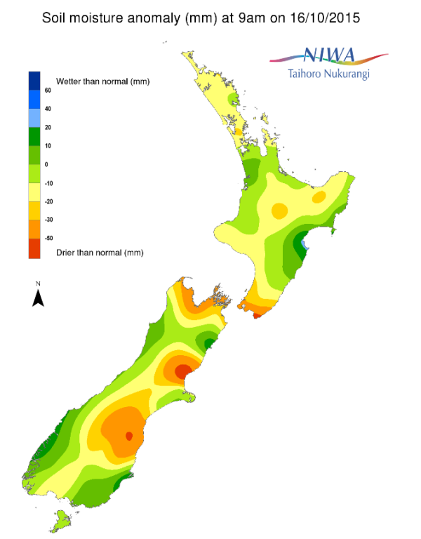
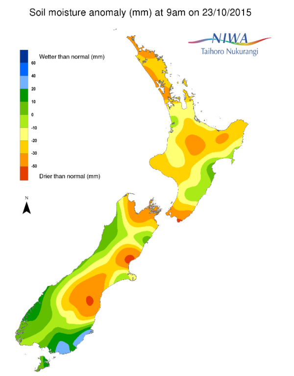
For the North Island, soil moisture levels decreased for nearly the whole of the island when compared to this time last week. Slightly below normal to below normal soil moisture levels for this time of year are now present for the majority of the island with the only exceptions being far western Waikato, Hawke’s Bay and northern Wairarapa regions where soil moisture is near normal for this time of year. The driest soil in the North Island exists in the lower part of the island, roughly south of a line from Levin to Castlepoint, where soil moisture levels have continued to drop over the past few weeks, and east of Wellington, where soils are severely drier than normal for this time of year.
NB: it should be noted due to time required to produce soil moisture maps, the effects of rainfall over the past 24 hours over the central and southern North Island have not yet been reflected in the most recent soil moisture map.
In the South Island, soil moisture has increased for much of the lower part of the island, from Fiordland to Dunedin, over the past week. Farther north, soils remain significantly to severely drier than normal for this time of year, particularly from about Lauder and Middlemarch north to near Winchmore. From near Christchurch to Darfield to Ashburton a relatively small region exists where soil moisture is near normal or slightly below normal for this time of year. However, from Rangiora to just north of the Waiau River soil moisture is severely drier than normal for this time of year. Additionally, drier than normal soils for this time of year have continued to develop in the Nelson region as well as parts of the Tasman and Marlborough regions. Elsewhere soils remain near normal for this time of the year.
Outlook
For the North Island, widespread and – for some – significant rain is forecast for the start of the long weekend. Widespread amounts of 5-15 mm are likely from this event with localised amounts in the central and northern North Island of 25-50 mm possible by early Sunday morning. After a couple of days of largely dry weather, another period of rain is likely to impact much of the island later on Tuesday into Wednesday, with unsettled and showery weather possible on Thursday and Friday. Consequently, soil moisture levels are likely to increase for the majority of the island by this time next week.
For the South Island, showers are likely for the island, in particular for areas along and west of the Divide as well as Southland and southwestern Otago through Sunday. Thereafter, low pressure and a cold front should bring widespread and potentially heavy rain for much of the western half of the island on Monday into Tuesday, from top to bottom. Wet weather may impact areas east of the Divide for the latter half of next week. As a result, soil moisture levels west of the Divide will likely remain steady or increase. Soil moisture levels will likely remain steady or possibly decrease from eastern Southland north through to mid-Canterbury. From near Christchurch north to Marlborough, soil moisture levels should remain steady, and depending on how much rainfall occurs next week, may increase a bit by this time next week.
Overall, a hotspot persists from southern sections of east Canterbury with another hotspot located in north-central parts of eastern Canterbury, roughly north of Christchurch to the Waiau River. For the North Island, a hotspot exists in an area near and east of the Tararua ranges and south of Masterton.
Background
Hotspot Watch a weekly advisory service for New Zealand media. It provides soil moisture and precipitation measurements around the country to help assess whether extremely dry conditions are imminent.
Soil moisture deficit: the amount of water needed to bring the soil moisture content back to field capacity, which is the maximum amount of water the soil can hold.
Soil moisture anomaly: the difference between the historical normal soil moisture deficit (or surplus) for a given time of year and actual soil moisture deficits.
Definitions: “Extremely” and “severely” dry soils are based on a combination of the current soil moisture status and the difference from normal soil moisture (see soil moisture maps at https://www.niwa.co.nz/climate/nz-drought-monitor/droughtindicatormaps)
Pictured below: Soil Moisture Anomaly Maps, relative to this time of year. On the left are values this time last week. On the right are the most recent values.


