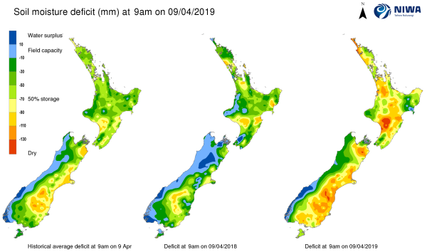
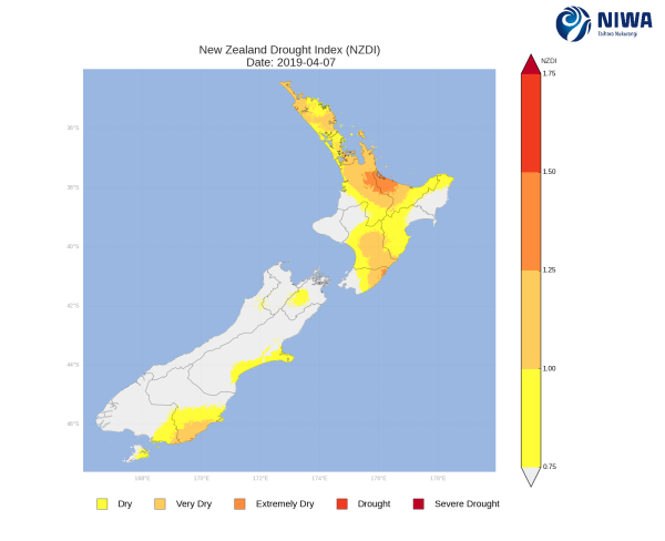
A weekly update describing soil moisture across the country to help assess whether severely to extremely dry conditions are occurring or imminent. Regions experiencing these soil moisture deficits are deemed “hotspots”. Persistent hotspot regions have the potential to develop into drought.
Facts: Soil Moisture
Across the North Island, soil moisture levels decreased in big parts of the island during the past week due to meagre rainfall. Conversely, the lower east coast and the far south (including Hawke’s Bay, coastal Wairarapa and Wellington) saw a soil moisture increase due to rainfall totals above average for the time of year. In addition, soil moisture increases were also observed in parts of Auckland and eastern Northland. The driest soils across the North Island compared to normal for this time of the year are found in western Northland, western Waikato and interior Manawatu-Wanganui, while the wettest soils for this time of the year are located in southern Gisborne and the Mahia Peninsula, and in Wellington City.
The majority of the hotspots in interior and western areas expanded in the past week. Hotspots are currently in place across western Northland and Aupouri Peninsula, a portion of central and western Waikato, southern Manawatu-Whanganui, and parts of southern Hawke’s Bay.
In the South Island, soil moisture decreases were observed across much of the island. However, soil moisture increases were observed in the Marlborough Sounds area and parts of the upper east coast due to rainfall totals above normal. The driest soils across the South Island compared to normal for this time of year are found in lower Southland along with central Marlborough, while the wettest soils are found in the Marlborough Sounds area.
South Island hotspots are currently found in portions of interior Marlborough, a disjointed line down the eastern coast from northern Canterbury to the Clutha District, and in small portions of lower Southland.
Outlook and Soil Moisture
In the North Island, a frontal passage is expected to bring rain to much of the island on Thursday (11 April). Moderate to heavy rain is anticipated in western and southern areas with isolated rainfall totals near 50 mm possible, while eastern areas may see rainfall totals of 15-20 mm. Showers may linger on Friday, but a ridge of high pressure is expected to build in and bring overall settled weather and a period of meagre rainfall. However, an onshore flow may continue to bring showers along the lower east coast and Hawke’s Bay well into next week.
Total rainfall amounts in the next week could reach 30-50 mm in western and southern areas, from lower Waikato to Wellington. Rainfall totals in Hawke’s Bay may exceed 25-30 mm, while rainfall for the rest of the island are expected to stay below 15-20 mm. Due to the anticipated rainfall in the next week, soil moisture increases would be expected in western areas and in the far south, likely weakening the hotspots in western Waikato and Manawatu-Wanganui. Meanwhile, the hotspots in the Far North and central Waikato may strengthen in the next week while the hotspot in Hawke’s Bay may remain constant.
In the South Island, the aforementioned frontal passage will bring short-lived, but heavy rainfall to western areas on Wednesday (10 April). 50-100 mm of rain will be common along the coast with rainfall totals potentially exceeding 200 mm in the ranges. The front will continue north and bring rain (up to 50mm) to the far northern regions on Thursday (11 April). A ridge of high pressure is expected to build in on Friday and bring an extended period of settled weather with meagre rainfall.
Due to the anticipated rainfall in the next week, soil moisture levels are expected to increase in western and northern areas but slightly decrease or remain constant in eastern areas. This will likely lead to the hotspot in interior Marlborough either weakening or dissipating in the upcoming week, while the remainder of the hotspots will likely remain the same or slightly strengthen.


