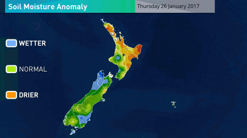
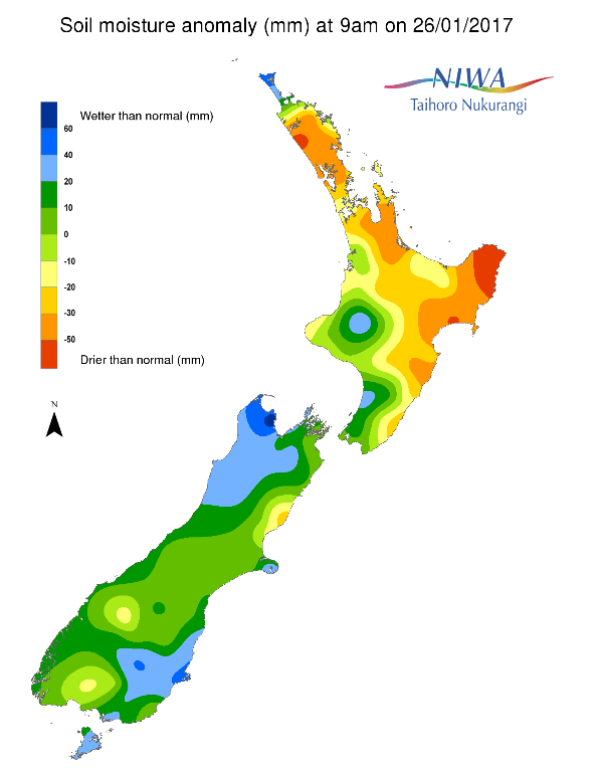
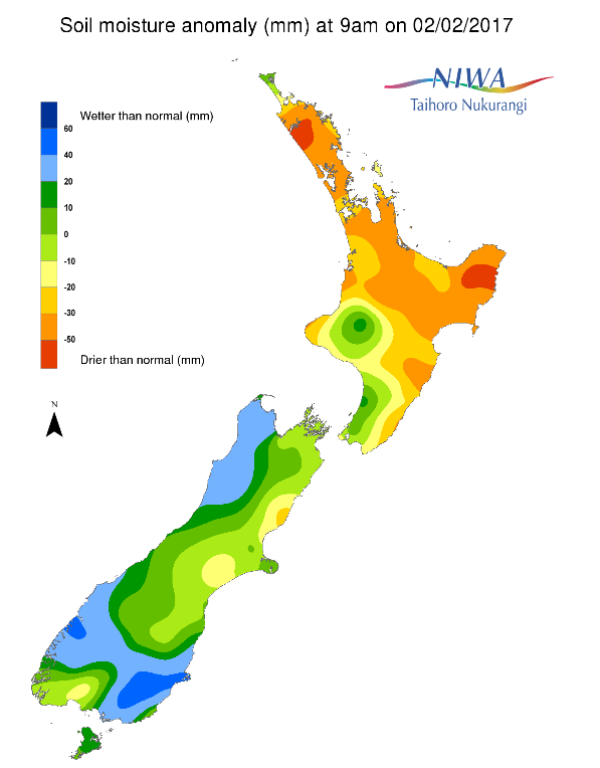
A weekly update describing soil moisture across the country to help assess whether severely to extremely dry conditions are occurring or imminent. Regions experiencing these soil moisture deficits are deemed “hotspots”. Persistent hotspot regions have the potential to develop into drought.

Facts: Soil Moisture
Across the North Island, soil moisture levels have generally decreased during the past week following persistent patterns of high pressure and rain-free weather. The most notable decreases occurred across the Bay of Plenty and Waikato. The driest soils across the North Island compared to normal for this time of year are found in Kaipara and Gisborne. The wettest soils for the time of year are found in the Ruapehu District, the southwest coast of Manawatu-Wanganui, and along the Kapiti Coast.
Hotspots remain in place across large portions of the North Island, including much of Northland, Auckland, Waikato (including the Coromandel Peninsula), and much of the east coast from Gisborne south to Masterton. Soils in these areas are severely to extremely drier than normal for this time of year. In addition, hotspot conditions have developed across parts of the Bay of Plenty over the past week.
Across the South Island, soil moisture levels have generally decreased during the past week, with the exception of the far southwest. The most substantial decreases were observed in the Kaikoura District and across Marlborough as westerly quarter winds promoted mostly dry weather. As a result, a small hotspot remains in the Hurunui District (northern Canterbury).
Outlook and Soil Moisture
For the North Island, while a few instances of rain are likely over the next week, significant alleviation of the dry soils in the north and east is unlikely. Total rainfall over the next week is expected to be between 5 and 15 mm across Hawke’s Bay and Gisborne (though higher amounts are possible about the ranges), generally less than 10 mm in Auckland and the Bay of Plenty, and less than 5 mm in Northland. Following dry weather this weekend into early next week, some rain is expected to track through these areas next Wednesday (February 8th) into Thursday (February 9th). Farther south and west, including Waikato, after beneficial rains Thursday and Thursday night, dry weather is also expected this weekend through Monday before some rain arrives Tuesday into Wednesday. Weekly rainfall is expected to be on the order of 10 to 15 mm.
Existing hotspots in the north and east of the North Island are forecast to remain the same or worsen slightly over the next week. The most significant change is expected over Northland where hotspot conditions will continue to worsen. Hotspot conditions are not expected to develop in the southwestern North Island over the next week.
Across the South Island, several rounds of rain are expected over the next week with the greatest amounts likely in the southwest. Weekly rainfall is expected to generally be near normal for this time of year except across interior Otago where rainfall is most likely to be below normal. Through Sunday, Fiordland is expected to have 25 to 50 mm and Westland 15 to 25 mm. Aside from light showers (less than 5 mm) across Southland, the remainder of the South Island is expected to have dry weather through Sunday. On Monday, locally heavy rainfall will stretch up the West Coast into the northwest Tasman District while lighter rains span Southland and southeastern Otago. Tuesday into Wednesday, beneficial rainfall is possible across northern Canterbury and Marlborough. Dry conditions are most likely on Thursday before more possible rain across the west and south to end the week.
Soil moisture levels are likely to remain about the same over the next week for many South Island locations. One possible exception is across interior Otago and Southland. These areas will be monitored for hotspot development in the coming week or two.


