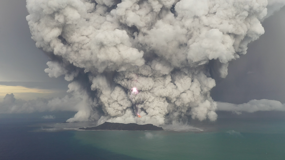
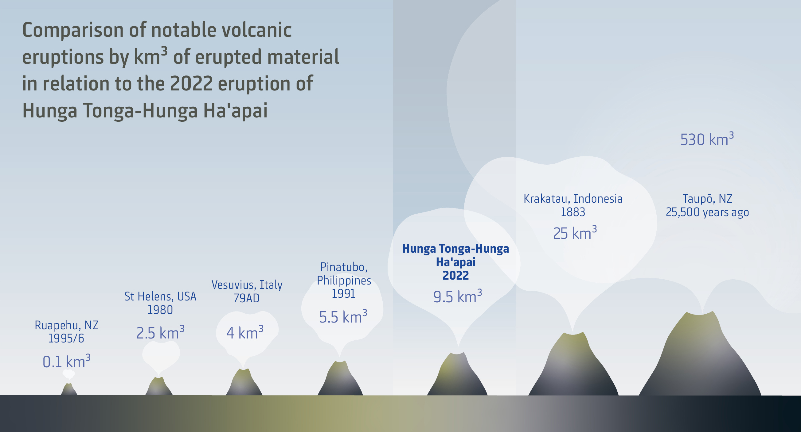
It went off with a bang. About half an hour into its most violent sequence, the Hunga Tonga-Hunga Ha’apai (HT-HH) submarine volcano erupted in the biggest atmospheric explosion ever recorded by modern instrumentation. The sonic boom was heard as far away as Canada.
The sheer power of the blast drove a column of rock, ash, water vapour and debris into the top layers of the stratosphere, causing electrical currents in space. Atmospheric shockwaves travelled around the globe three times, lifting cloud formations in the United Kingdom, some 16,500km away.
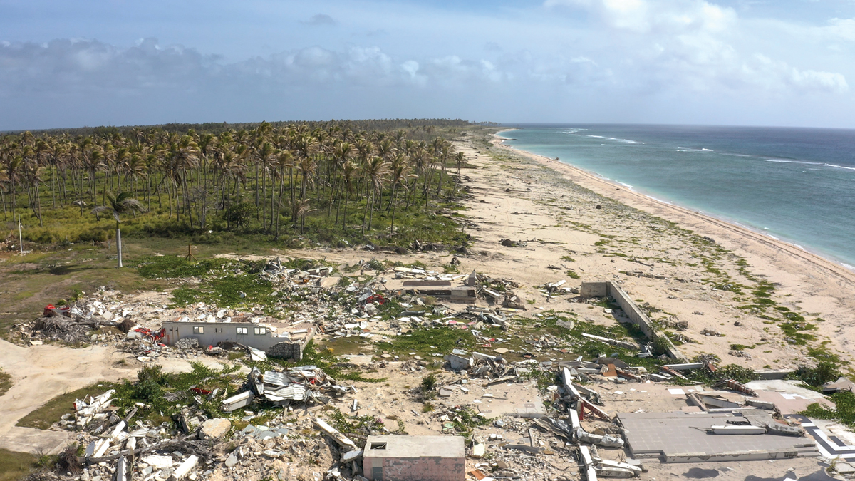
The force of the explosion lifted an initial wave 90m above the caldera, sending tsunami racing out across the Pacific at up to 1,000km/h. Waves up to 19m high smashed into the western coast of Tonga, with smaller, but still damaging swells, reaching the shores of New Zealand, Japan, Russia and the Americas.
Waves even swept in under the Antarctic ice sheets.
The last volcano to generate this scale of physical impact was the infamous 1883 eruption of Krakatau, west of Java.
As quickly as the power and scale of the cataclysmic blast started to become clear, questions also bubbled to the surface.
What exactly happened off the Tongan coast and why was this blast so powerful? Why did the eruption cloud travel to such heights, yet the volcano itself emit far less toxic ash than expected? And what was behind those powerful waves that swept through both the atmosphere and the ocean – waves of a scale unseen in the modern scientific era?
Perhaps even more importantly, what does HT-HH’s cataclysmic eruption mean, not just for the neighbouring island of Tonga, but for all nations with submarine volcanos nearby?
Amongst all these questions, one thing was certain: HT-HH offered a unique opportunity to bring modern research techniques to the aftermath of the most powerful volcanic eruption since Krakatau.
Prior to 15 January, HT-HH presented as a classic underwater volcanic cone, rising 2,000m directly out of the Pacific seafloor, 65km northwest of Tongatapu, Tonga’s main island. The 4km wide caldera was about 150m below sea level, with a small island breaking through the ocean surface.
In the days after the eruption, atmospheric scientists used equipment including satellites, lasers and research balloons to analyse the volcano’s colossal plume, while researchers on the ground gathered samples from the dense ash layers blanketing Tongatapu and nearby islands.
But the real answers as to what had happened lay hidden beneath the waves: in the changes to the volcano's underwater structure and the impact on the seabed nearby and the surrounding waters.
Such a global event required a global effort to unlock its mysteries. Enter NIWA’s ocean science specialists, who in collaboration with the Kingdom of Tonga, Japan’s The Nippon Foundation, and UK robotics company SEA-KIT, launched an international research mission to HT-HH.
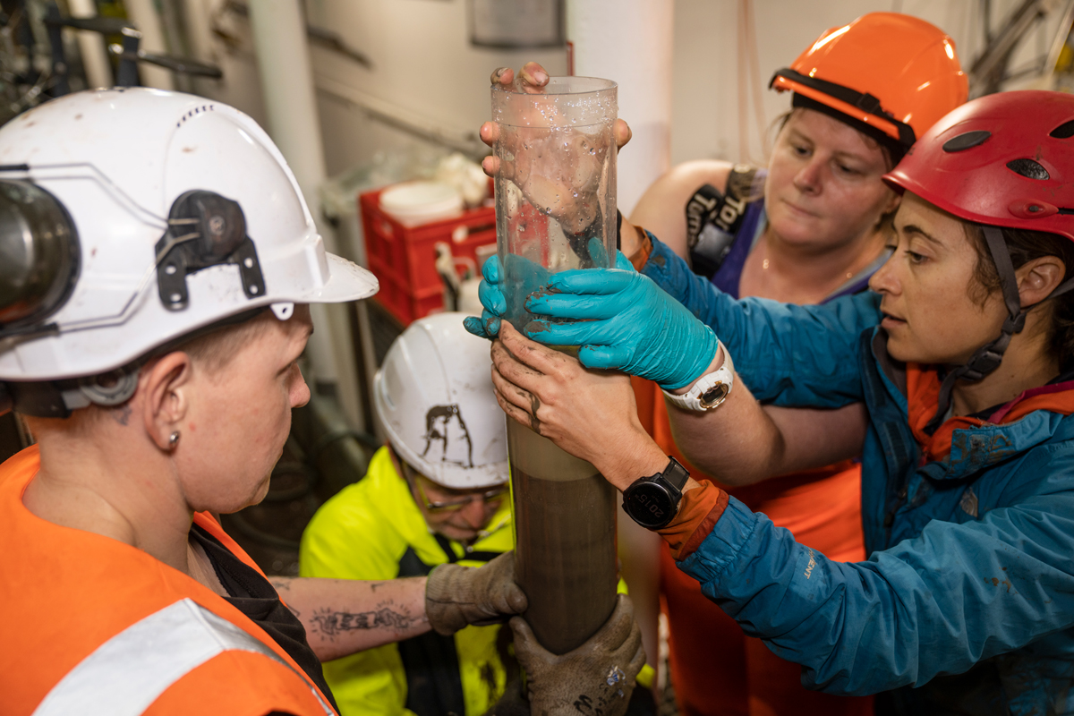
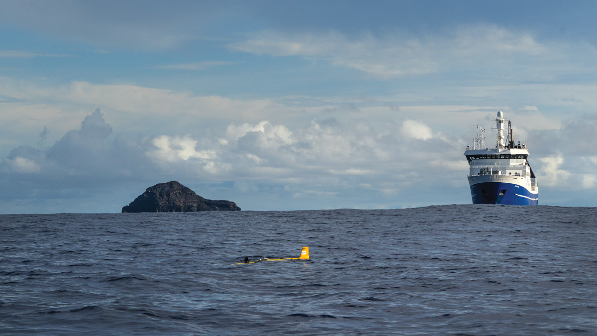
The NIWA-Nippon Foundation Tonga Eruption Seabed Mapping Project (TESMaP) was formed, and NIWA’s research flagship RV Tangaroa set sail on a month-long voyage to comprehensively remap the underwater volcano, along with detailed investigations into the surrounding seabed, ocean waters and marine life.
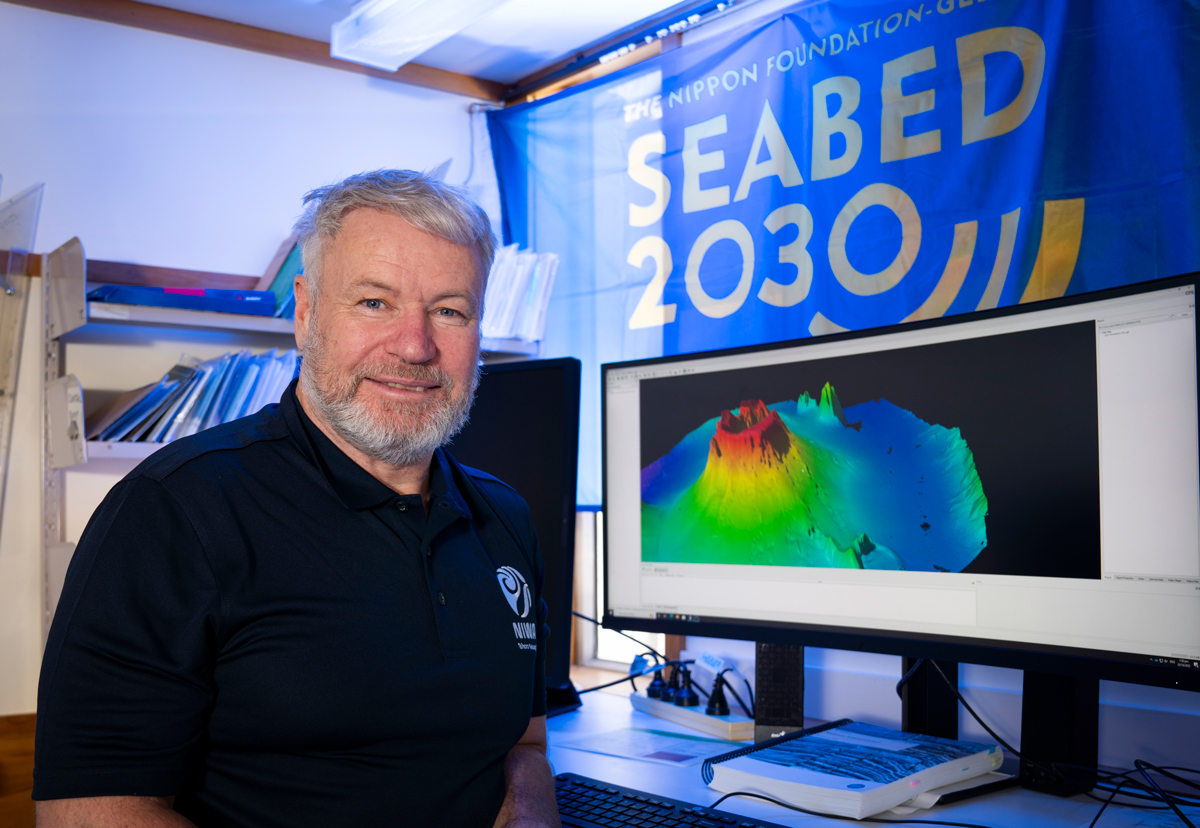
“The violence of this eruption surprised everybody, and it has implications not just for Tonga, but for the whole Pacific Ring of Fire. In fact, it affects any nation with undersea volcanos nearby – New Zealand, Japan, Indonesia, the Caribbean, anyone,” says expedition leader and marine geologist Kevin Mackay.
“The evidence was under the sea. We needed to find out what actually happened.”
Complete with marine geologists, biologists, oceanographers and geochemists, the 30-strong team meticulously mapped 22,000km2 of seabed using Tangaroa’s high resolution multibeam echosounder. They recovered thousands of physical samples and environmental readings from throughout the water column and the seafloor hundreds of metres below, while also capturing 32 hours of underwater video and more than 7,000 photographs.
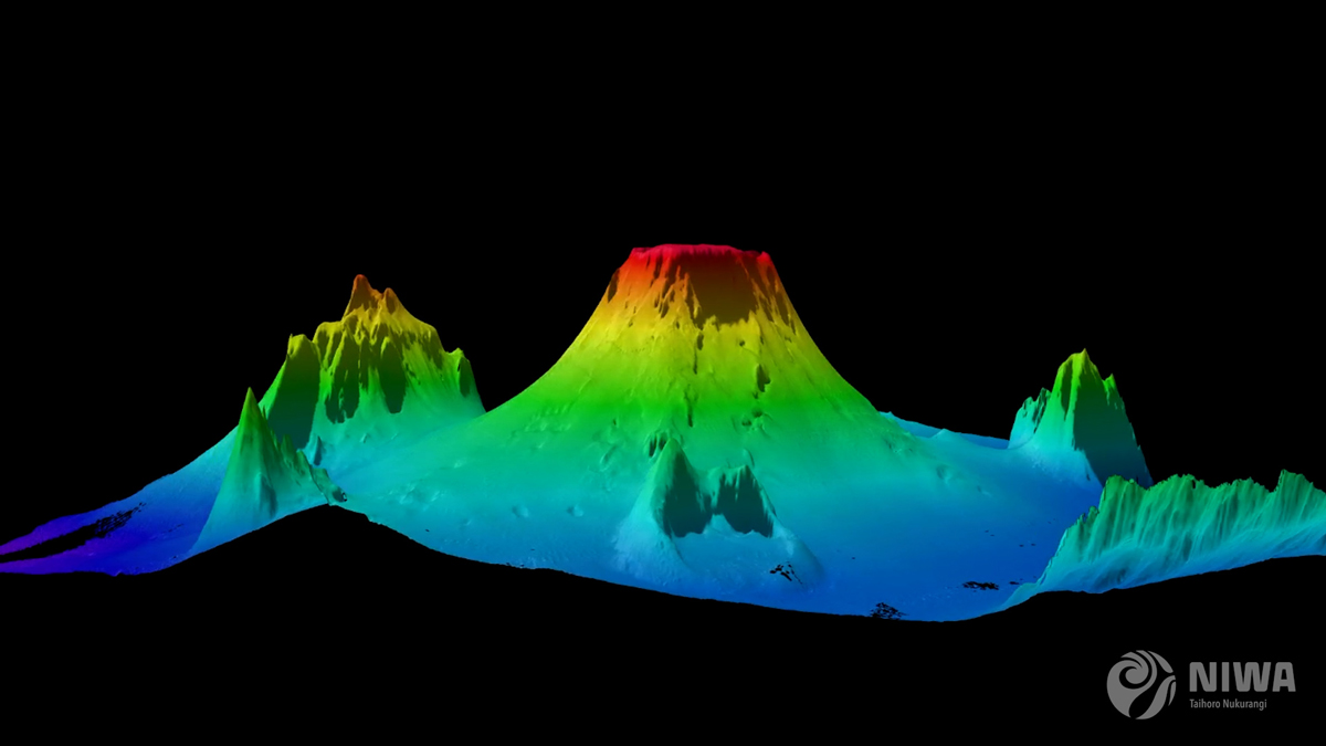
In a stroke of good fortune, HT-HH had been comprehensively mapped in 2016, giving the scientists aboard Tangaroa a detailed picture of the volcano’s pre-eruption structure.
Eruptions of this magnitude, like Mount Pinatubo or Krakatau, typically blow themselves apart, exploding through their own sides or collapsing back down into the caldera.
But when the first 3D multibeam images started turning up on Tangaroa’s screens, Mackay says the researchers were stunned.
“With an explosion that violent, you would expect that the whole volcano would have been obliterated. But it wasn’t – the underwater mountain itself was virtually intact. I couldn’t believe it.”
Mackay says the lack of damage to HT-HH’s cone is highly significant. He says it points to an eruption, probably fuelled by the sudden contact of superheated volcanic material with seawater, acting like a massive shotgun blast and shooting straight up and out of the underwater caldera.
The power of that explosive interaction fired tens of millions of tonnes of volcanic debris and water vapour 58km into the atmosphere.
This, he says, helps explain the massive power of HT-HH and the scale of the atmospheric shockwave and sonic boom that were unleashed.
But HT-HH did not expend all its energy firing into the skies above. As more data and imagery came on board, the team started to gain further insight.
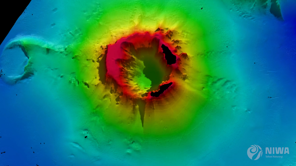
The mapping began to reveal deep scars gouged into the volcano’s underwater flanks as well a complex network of new channels carved into the surrounding seabed.
While lava flows may look compelling, Mackay says the most destructive output from a volcano are the pyroclastic flows. These superheated avalanches of rock, gas and ash poured out of HT-HH’s underwater caldera, scouring down the sides of the cone and rumbling out, in some cases, more than 80kms across the seabed.
“The pyroclastic flow is the most violent material produced by a volcano. These are hugely turbulent flows of rock and ash and steam, all mixed up and jumbled together like a giant tumble dryer.
“Underwater these actually become even more destructive because you get steam mixed into it and this creates these hundreds of tonnes of rumbling rock, just sweeping out and gouging a path through seafloor.”
It was these destructive forces that engulfed a section of the undersea communications cable linking Tonga to the outside world. But rather than a clean break, the survey revealed 80kms of cable torn and twisted into a tangled mess, as the devastating flows swept back and forth across the contours of seabed.
Core sampling and video reconnaissance shows that once these violent flows subsided, the ocean floor was left covered, up to 30m deep, in a thick layer of volcanic debris and ash.
“We were expecting to see what we call the typical seafloor life in the deep ocean, lots of animal burrows, lots of tracks, lots of snails and crabs. We just saw desert. I’ve never seen anything quite like it. Mile after mile of this devastation,” says Mackay.
Tests also revealed a dense ash layer, metres deep, still present in the upper water column near the volcano and yet to settle on the seafloor.
Biogeochemist Dr Sarah Seabrook says this could have a myriad of impacts on the ecosystem.
In the immediate aftermath of the eruption, nutrients and trace elements from ash helped fertilise an algal bloom. But Seabrook cautions that the unexpected persistence of the ash was coupled with low oxygen readings which could have implications for ocean services, such as food production and carbon sequestration.
Despite the destruction, the team did find some small patches of sea life as close as 15km from HT-HH. Marine biologist Dr Malcolm Clark says it appears these pockets were sheltered from the volcanic flows, or out of range of the thick ash fall.
“Some surrounding seamounts have pockets of normal biodiversity, such as corals, sponges, starfish, and mussels, indicating the resilience of such marine ecosystems and giving some hope for recovery.”
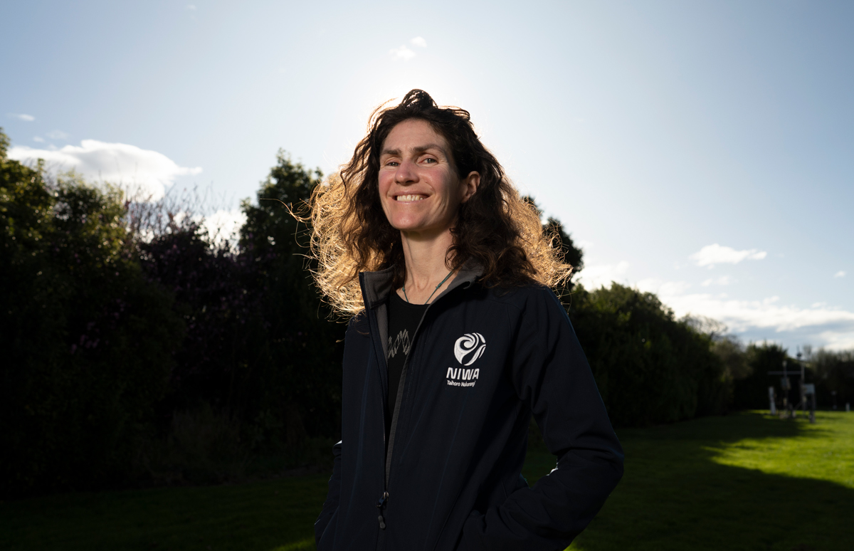
Dr Emily Lane is a hydrodynamic scientist at NIWA and has been, in equal parts, intrigued and puzzled by the impact of HT-HH’s explosion.
She says tsunami are most commonly associated with earthquakes, which cause sharp movements or landslides on the seafloor, displacing large volumes of water.
Tsunami from volcanic eruptions, however, are rare. Less than a hundred have been recorded in the past two centuries and these have been localised and small.
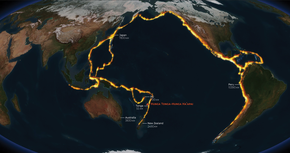
HT-HH, by contrast, sent a sequence of waves up to 19m high surging towards Tonga’s western coast, riding up beaches and smashing homes and holiday resorts. Waves also swept right around the Pacific, with damage reports coming in from New Zealand, Japan, Russia and the coastlines of North and South America.
Remarkably, due it seems to a combination of sparse population, early warning and the time of the event, only four lives were lost when the huge waves swept into Tonga.
Two people, however, were also killed 10,000kms away in Peru when 2m waves washed ashore.
In a surprising development, small tsunami waves were even detected in the Caribbean and the Mediterranean seas.
“When the volcano erupted, I wasn’t expecting the impact to be nearly as big as it was. It caused one of the few tsunami powerful enough to spread across the globe,” says Lane.
“Usually with a volcanic eruption, several things can displace water, including the force of the blast itself, expulsion of material that lands back in the water and creates waves, or collapse of the volcano’s flank that acts like a landslide,” Lane explains.
While the structure of HT-HH remained intact, Lane thinks the power of the blast and the massive pyroclastic flows played a significant factor in the complex pattern of tsunami generated. This, along with another little-known phenomena, a meteotsunami.
Meteotsunamis are created by fast-moving changes in atmospheric pressure, usually from storms, which push the water ahead of them. They account for just 3% of historical tsunami events only, and up until now have been thought to have only small, local effects.
“We’ve been offered a bit of a lifeline here – a once in a lifetime chance to study an event like this and learn from it. We needed to know why it bucked the trend, so we have been working with colleagues from several organisations to combine our data and model different scenarios.
“We’re using information from DART buoys, which are real-time tsunami monitoring systems scattered around the world’s oceans, satellite data, and seismometers to pull together the pieces and figure out what happened,” Lane says.
In this case, it was the atmospheric waves created by the massive shotgun blast from the volcano that did the trick, helping to drive waves that were global in their impact.
“We discovered that the atmospheric waves were travelling at the same speed as the tsunami that was generated by the underwater impacts. The atmospheric wave drove energy into the tsunami and essentially supercharged it.
“Additionally, because meteotsunamis are caused by air pressure waves, they don’t stop at the coast. Air waves can leapfrog land masses, so it didn’t matter that America was in the way, they just kept going and regenerated a tsunami on the other side,” says Lane.
It’s these unique mechanics that meant HT-HH’s waves went further, moved faster, and hit stronger than anyone could have predicted.
“Volcanic meteotsunamis are a game changer. While we knew about this phenomenon in theory, we’ve never actually seen it in real-time.”
Lane says lessons from HT-HH must be factored into future tsunami calculations, particularly for more densely populated countries lying along active tectonic zones such as New Zealand, Japan, the United States or Chile.
“We need to understand how big a tsunami a volcanic eruption can cause and how worried we should be."
“If this eruption had happened near New Zealand or Japan, for example, we’d be looking at very different outcomes,” says Lane.
Perhaps the last word should go to Kevin Mackay, recalling first seeing the remnants of Hunga Tonga-Tonga Ha’apai, from the bridge of Tangaroa.
He says it was a sobering sight.
“The sun came up and there were these islands, just ripped apart. They ooze violence, they’re black and charred and sharp and jagged. They just look like devastation."
“You really get a true sense of the violence that happened."
“You have to know that these volcanos can erupt this way, if you are going to prepare for them.”
This story forms part of Water and Atmosphere - December 2022, read more stories from this series.